IMAGES TAKEN NEAR TO
New Heys Way, BOLTON, BL2 4AG
Introduction
This page details the photographs taken nearby to New Heys Way, BL2 4AG by members of the Geograph project.
The Geograph project started in 2005 with the aim of publishing, organising and preserving representative images for every square kilometre of Great Britain, Ireland and the Isle of Man.

There are currently over 7.5m images from over14,400 individuals and you can help contribute to the project by visiting https://www.geograph.org.uk
Image Map
Images are licensed for reuse under creativecommons.org/licenses/by-sa/2.0
Notes
- Clicking on the map will re-center to the selected point.
- The higher the marker number, the further away the image location is from the centre of the postcode.
Image Listing (5 Images Found)
Images are licensed for reuse under creativecommons.org/licenses/by-sa/2.0
Image
Details
Distance
1
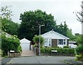
New Heys Way becomes Catterall Crescent
A residential area in Harwood.
Image: © philandju
Taken: 28 Jul 2020
0.05 miles
2
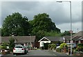
New Heys Way
A residential area in Harwood.
Image: © philandju
Taken: 28 Jul 2020
0.18 miles
3
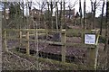
Mysterious structure
The fenced off concrete base with a concrete monument atop is not detailed on the map. It seems that the structure is owned by the Coal Authority and could be a capped mineshaft.
Image: © philandju
Taken: 2 Feb 2013
0.19 miles
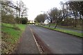
5
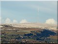
Winter Hill from Harwood
In the mid ground, Wilton Quarry, now disused. In the foreground, part of Bromley Cross.
Image: © philandju
Taken: 15 Jan 2016
0.20 miles