IMAGES TAKEN NEAR TO
Park View, BOLTON, BL1 7LE
Introduction
This page details the photographs taken nearby to Park View, BL1 7LE by members of the Geograph project.
The Geograph project started in 2005 with the aim of publishing, organising and preserving representative images for every square kilometre of Great Britain, Ireland and the Isle of Man.

There are currently over 7.5m images from over14,400 individuals and you can help contribute to the project by visiting https://www.geograph.org.uk
Image Map
Images are licensed for reuse under creativecommons.org/licenses/by-sa/2.0
Notes
- Clicking on the map will re-center to the selected point.
- The higher the marker number, the further away the image location is from the centre of the postcode.
Image Listing (64 Images Found)
Images are licensed for reuse under creativecommons.org/licenses/by-sa/2.0
Image
Details
Distance
1
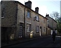
Playfair Street, Eagley Bank
Probably, these houses would have been built to house workers at the nearby Eagley Mills where cotton was spun. The stone houses in Eagley Bank are a mix of small cottages, larger houses and a few more substantial dwellings, so that all grades of workers were suitably accommodated.
Image: © philandju
Taken: 19 Oct 2011
0.01 miles
2
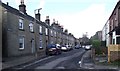
Stone Cottages at Eagley Bank
In North Bolton. One side of the street (Park Row) is stone cottages, the other, a brick terrace built at a later date.
Image: © philandju
Taken: 19 Oct 2011
0.02 miles
3
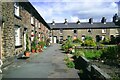
Park View, Eagley Bank
Looking to the east, depicting the northernmost buildings of Park View.
Image: © Earnest Lad
Taken: 19 Jan 2004
0.03 miles
4
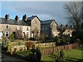
Park View, Eagley Bank
View across northern side of Park View looking south-east towards the other side of Park View, with Playfair Street in the middle distance. Winter photo from 2007
Image: © Earnest Lad
Taken: 6 Apr 2007
0.03 miles
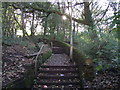
5
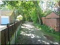
Vew of ancient path from Eagley Bank to Blackburn Road
View westwards of footpath that runs from Playfair Street/The Gardens towards Makants Farm and Blackburn Road (A666).
Image: © Earnest Lad
Taken: 30 Sep 2006
0.06 miles
6
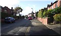
Westcliffe Road, Sharples
Built pre - war, the short residential road connects Andrew Lane to Blackburn Road.
Image: © philandju
Taken: 19 Oct 2011
0.09 miles
7
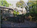
Makant's Farm, Sharples
Not a working farm for a number of years, the farm land is now given over to housing, and only the farmhouse and a converted barn remain.
Image: © philandju
Taken: 19 Oct 2011
0.10 miles
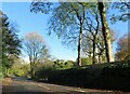
8
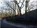
Eagley Bank
The old road to Eagley Mills, now redundant as a road and used only as a footpath.
Image: © philandju
Taken: 26 Jan 2018
0.10 miles
9
Footpath at Eagley
Connecting Eagley Brow with Eagley Way, the path would have been a direct route from Eagley to Eagley Bank, and would have been used by those workers at Eagley Mills who lived at Eagley Bank.
Image: © philandju
Taken: 19 Oct 2011
0.11 miles
10
Eagley Way
Leading from Blackburn Road (A666) to Eagley.
Image: © philandju
Taken: 4 Nov 2022
0.12 miles