IMAGES TAKEN NEAR TO
Blackburn Road, BOLTON, BL1 7JL
Introduction
This page details the photographs taken nearby to Blackburn Road, BL1 7JL by members of the Geograph project.
The Geograph project started in 2005 with the aim of publishing, organising and preserving representative images for every square kilometre of Great Britain, Ireland and the Isle of Man.

There are currently over 7.5m images from over14,400 individuals and you can help contribute to the project by visiting https://www.geograph.org.uk
Image Map
Images are licensed for reuse under creativecommons.org/licenses/by-sa/2.0
Notes
- Clicking on the map will re-center to the selected point.
- The higher the marker number, the further away the image location is from the centre of the postcode.
Image Listing (29 Images Found)
Images are licensed for reuse under creativecommons.org/licenses/by-sa/2.0
Image
Details
Distance
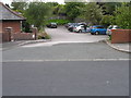
1
Open space by Northland Road
Northland Road at the far side appears to have been blocked off but remains as a private access road.
Image: © Bill Boaden
Taken: 28 Dec 2011
0.05 miles
2
Houses on Andrew Lane
In Sharples, Bolton.
Image: © philandju
Taken: 9 Dec 2021
0.05 miles
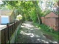
3

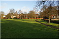
Andrew Lane park, Sharples
Though small, this green area is a pleasant haven from the A666 to the right of the scene. The low beech hedge on the right, at least 50 years old, is a fine sight in late autumn when the leaves turn brown.
Image: © philandju
Taken: 19 Oct 2011
0.05 miles
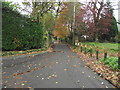
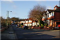
4
Westcliffe Road, Sharples
Built pre - war, the short residential road connects Andrew Lane to Blackburn Road.
Image: © philandju
Taken: 19 Oct 2011
0.13 miles
5
Sweetloves Lane, Sharples, Bolton
At the junction with Ivy Bank Close. The lane joins Blackburn Road (A666) and Belmont Road (A675), but is now restricted by a no entry sign at the Blackburn Road end. Apart from a pre-first world war farmhouse and a few post-second world war houses, the houses are inter-wars, and are substantial and desirable residences.
Image: © philandju
Taken: 11 Nov 2011
0.15 miles
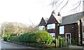
6
Entrance to Medical Centre, Kermoor Avenue
Image: © Alex McGregor
Taken: 15 Jun 2011
0.17 miles
7
Vew of ancient path from Eagley Bank to Blackburn Road
View westwards of footpath that runs from Playfair Street/The Gardens towards Makants Farm and Blackburn Road (A666).
Image: © Earnest Lad
Taken: 30 Sep 2006
0.19 miles
8
Astley Bridge Mill (3)
Courtyard at the northern end of the building.
Image: © Alan Murray-Rust
Taken: 25 Jul 2012
0.19 miles
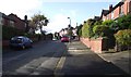
9
Kermoor Avenue
A quiet residential road.
Image: © Bill Boaden
Taken: 28 Dec 2011
0.19 miles
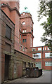
10
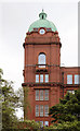
Astley Bridge Mill (1)
The water tower at the north west corner of the building.
Image: © Alan Murray-Rust
Taken: 25 Jul 2012
0.20 miles