IMAGES TAKEN NEAR TO
Belmont Road, BOLTON, BL1 7AF
Introduction
This page details the photographs taken nearby to Belmont Road, BL1 7AF by members of the Geograph project.
The Geograph project started in 2005 with the aim of publishing, organising and preserving representative images for every square kilometre of Great Britain, Ireland and the Isle of Man.

There are currently over 7.5m images from over14,400 individuals and you can help contribute to the project by visiting https://www.geograph.org.uk
Image Map (Loading...)


Getting Data...Please wait
Leaflet Map data © OpenStreetMap
Images are licensed for reuse under creativecommons.org/licenses/by-sa/2.0
Notes
- Clicking on the map will re-center to the selected point.
- The higher the marker number, the further away the image location is from the centre of the postcode.
Image Listing (56 Images Found)
Images are licensed for reuse under creativecommons.org/licenses/by-sa/2.0
Image
Details
Distance
1
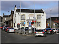
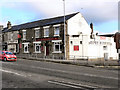
Three Pigeons
At the junction of Belmont Road and Blackburn Road.
Image: © David Dixon
Taken: 20 Nov 2010
0.01 miles
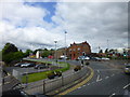
2
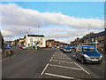
Blackburn Road/Belmont Road Junction
The junction of the A675 (Belmont Road), to the left, and the A666 (Blackburn Road).
Image: © David Dixon
Taken: 20 Nov 2010
0.02 miles
5
The Pineapple
Public house at the corner of Blackburn Road and Moss Bank Way.
Image: © David Dixon
Taken: 20 Nov 2010
0.04 miles
6
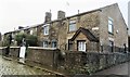
Hoyle Street, Astley Bridge
The cottages are Grade 2 listed.
Image: © philandju
Taken: 26 Nov 2017
0.04 miles
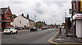
7
Moss Bank Way crosses Blackburn Road at Astley Bridge
The library and Copier outlet on view
Image: © Raymond Knapman
Taken: 30 Jul 2015
0.05 miles
8
The Gospel Hall
An evangelical free church on Maxwell Street, Astley Bridge, opened in 1939.
Image: © philandju
Taken: 1 Apr 2022
0.05 miles
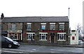
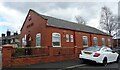
9
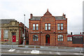
Public Offices, Astley Bridge
After becoming an Urban District Council in 1894, Astley Bridge clearly had to provide itself with a centre of administration, and built this office building in 1896. Just two years later it was absorbed into the expanding Bolton County Borough.
The building is an attractive example of brick and terracotta which was much in favour at the time. It is no longer in public ownership and houses a private firm.
Image: © Alan Murray-Rust
Taken: 25 Jul 2012
0.05 miles
10
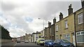
Belmont Road, Astley Bridge
The pub on the right is the Brewery Tap, formerly the Carters Arms.
Image: © philandju
Taken: 1 Apr 2022
0.05 miles