IMAGES TAKEN NEAR TO
Perendale Rise, BOLTON, BL1 6RY
Introduction
This page details the photographs taken nearby to Perendale Rise, BL1 6RY by members of the Geograph project.
The Geograph project started in 2005 with the aim of publishing, organising and preserving representative images for every square kilometre of Great Britain, Ireland and the Isle of Man.

There are currently over 7.5m images from over14,400 individuals and you can help contribute to the project by visiting https://www.geograph.org.uk
Image Map
Images are licensed for reuse under creativecommons.org/licenses/by-sa/2.0
Notes
- Clicking on the map will re-center to the selected point.
- The higher the marker number, the further away the image location is from the centre of the postcode.
Image Listing (52 Images Found)
Images are licensed for reuse under creativecommons.org/licenses/by-sa/2.0
Image
Details
Distance

3
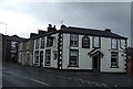
The Brewery Tap
The Brewery Tap, formerly the Carters Arms, at the corner of Ramsey Street and Belmont Road.
Image: © David Dixon
Taken: 20 Nov 2010
0.04 miles
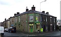
4
The Brewery Tap
The Brewery Tap, formerly the Carters Arms, at the corner of Ramsey Street and Belmont Road.
Image: © David Dixon
Taken: 20 Nov 2010
0.04 miles
7
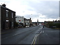
Belmont Road, Bolton
Climbing towards the moors.
Image: © Richard Webb
Taken: 22 Nov 2021
0.07 miles
8
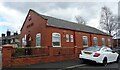
The Gospel Hall
An evangelical free church on Maxwell Street, Astley Bridge, opened in 1939.
Image: © philandju
Taken: 1 Apr 2022
0.07 miles
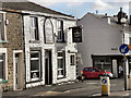
9
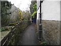
The Ginnel, Astley Bridge
This alleyway is much used by pedestrians heading for the shops in Astley Bridge. In earlier times, where the fence is, on the left, there stood the wall of a mill, thus giving rise to the local name for the alley of "The Ginnel". Ginnel is a northern dialect word meaning a passageway between two buildings.
Image: © philandju
Taken: 11 Nov 2011
0.07 miles
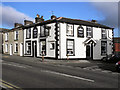
10
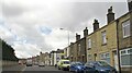
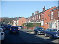
Belmont Road, Astley Bridge
The pub on the right is the Brewery Tap, formerly the Carters Arms.
Image: © philandju
Taken: 1 Apr 2022
0.07 miles