IMAGES TAKEN NEAR TO
Oldhams Lane, BOLTON, BL1 6PN
Introduction
This page details the photographs taken nearby to Oldhams Lane, BL1 6PN by members of the Geograph project.
The Geograph project started in 2005 with the aim of publishing, organising and preserving representative images for every square kilometre of Great Britain, Ireland and the Isle of Man.

There are currently over 7.5m images from over14,400 individuals and you can help contribute to the project by visiting https://www.geograph.org.uk
Image Map
Images are licensed for reuse under creativecommons.org/licenses/by-sa/2.0
Notes
- Clicking on the map will re-center to the selected point.
- The higher the marker number, the further away the image location is from the centre of the postcode.
Image Listing (17 Images Found)
Images are licensed for reuse under creativecommons.org/licenses/by-sa/2.0
Image
Details
Distance
1
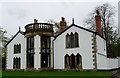
Bosco House
Originally named The Lees, the house was taken over by The Salesians of Don Bosco as accommodation for the priests who ran the adjacent Thornleigh College Grammar School and was renamed Bosco House. The building is now converted into apartments. The building is Grade 2 listed. The Salesian Order is named for St. Francis of Sales who was Don (St. John) Bosco's inspiration when he founded the order to educate children.
Image: © philandju
Taken: 24 Apr 2018
0.02 miles
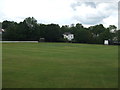
2
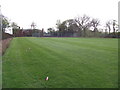
School playing field and school buildings
The "first eleven" football pitch at Thornleigh College (or it was in my day). Sadly I never got to play on it. The building in the background was where some of the school teachers (RC priests) lived. The empty pop bottle in the foreground is de riguer these days.
Image: © Phil Platt
Taken: 12 Apr 2011
0.04 miles
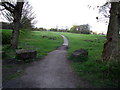
3
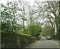
Sharples Park
On the right, but out of sight, is Thornleigh Salesian College, and behind the wall on the left, also out of sight, are the school playing fields.
Image: © philandju
Taken: 1 Apr 2022
0.08 miles
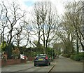
4
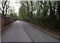
Moss Lea
Now a macadamed road leading past some gentrified pre-war houses to Raveden Wood, in the 1950s, this was a rutted and mostly muddy farm track. Thornleigh Salesian College - a secondary school - grounds are over the brick wall on the left.
Image: © Phil Platt
Taken: 12 Apr 2011
0.08 miles
5
Astley Bridge Cricket Club
Astley Bridge CC's Sharples Park ground.
Image: © BatAndBall
Taken: 20 Jun 2012
0.14 miles
6
Barlow Park
One entrance to this public amenity.
Image: © Phil Platt
Taken: 12 Apr 2011
0.16 miles
7
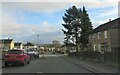
Athlone Avenue
Council housing in north Bolton.
Image: © philandju
Taken: 6 Jan 2023
0.17 miles
8

Broad O' Th' Lane, Astley Bridge, Bolton
The lane originally connected Moss Bank Way (the ring road, A58) with Belmont Road (A675), but in the 1970s it became a rat run for vehicles avoiding the A58/A666 junction a few hundred yards away. The Council, much to the relief of residents, blocked the lane to through traffic just behind the photographer's position. This section of the lane is once more a quiet and pleasant backwater.
Image: © philandju
Taken: 11 Nov 2011
0.18 miles
9

Flats on Moss Bank Way
At the junction of Broad o'th' Lane, Sharples Park and Moss Bank Way.
Image: © philandju
Taken: 19 Apr 2021
0.18 miles
10
Broad o' th' Lane
Originally the lane connected Moss Bank Way (A58) to Belmont Road (A675). It became a rat run for motorists avoiding the notoriously busy Astley Bridge junction of the A58, the A675 and the A666 a little further to the east. No doubt to the relief of residents, it has now been made into a cul de sac half way up its length, thus preventing through traffic.
Image: © philandju
Taken: 1 Apr 2022
0.19 miles