IMAGES TAKEN NEAR TO
Glentress Mews, BOLTON, BL1 5JS
Introduction
This page details the photographs taken nearby to Glentress Mews, BL1 5JS by members of the Geograph project.
The Geograph project started in 2005 with the aim of publishing, organising and preserving representative images for every square kilometre of Great Britain, Ireland and the Isle of Man.

There are currently over 7.5m images from over14,400 individuals and you can help contribute to the project by visiting https://www.geograph.org.uk
Image Map
Images are licensed for reuse under creativecommons.org/licenses/by-sa/2.0
Notes
- Clicking on the map will re-center to the selected point.
- The higher the marker number, the further away the image location is from the centre of the postcode.
Image Listing (5 Images Found)
Images are licensed for reuse under creativecommons.org/licenses/by-sa/2.0
Image
Details
Distance
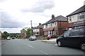
2
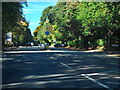
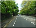
Chorley New Road, Heaton
The A673, Chorley New Road, near the entrance to Overdale Crematorium.
Image: © David Dixon
Taken: 25 Sep 2010
0.12 miles
3
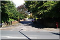
Albert Road, Bolton
A quiet residential road off Chorley New Road.
Image: © Bill Boaden
Taken: 22 Sep 2012
0.20 miles
5
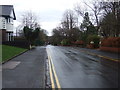
Devonshire Road Heaton
View south down Devonshire Road towards the junction with Lonsdale Rd. The junction with Lowndes St is just behind the photographer. Most of the houses are between the wars semi-detached red brick houses.
Image: © Nigel Mykura
Taken: 3 Sep 2015
0.25 miles