IMAGES TAKEN NEAR TO
Sterratt Street, BOLTON, BL1 4RY
Introduction
This page details the photographs taken nearby to Sterratt Street, BL1 4RY by members of the Geograph project.
The Geograph project started in 2005 with the aim of publishing, organising and preserving representative images for every square kilometre of Great Britain, Ireland and the Isle of Man.

There are currently over 7.5m images from over14,400 individuals and you can help contribute to the project by visiting https://www.geograph.org.uk
Image Map (Loading...)


Getting Data...Please wait
Leaflet Map data © OpenStreetMap
Images are licensed for reuse under creativecommons.org/licenses/by-sa/2.0
Notes
- Clicking on the map will re-center to the selected point.
- The higher the marker number, the further away the image location is from the centre of the postcode.
Image Listing (56 Images Found)
Images are licensed for reuse under creativecommons.org/licenses/by-sa/2.0
Image
Details
Distance
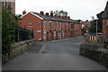
1
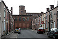
Vincent Street, Gilnow
Archetypal mill town scene - terrace houses developed close up to the textile mill. Often such streets were developed by mill owners for their employees as there would have been no other significant volume of housing nearby.
Image: © Alan Murray-Rust
Taken: 25 Jul 2012
0.02 miles
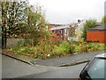
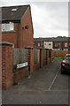
3
Back Vincent Street
On the right the rear of the houses seen in http://www.geograph.org.uk/photo/3079626. The back street provided access for the refuse and night soil carts. This is a relatively wide example, and the original setted surface has been repaved with a bituminised surface.
Image: © Alan Murray-Rust
Taken: 25 Jul 2012
0.04 miles
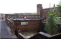
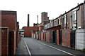
6
Bridgewater Street, Gilnow
The bottom of the group of terraced streets alongside Gilnow Mill.
Image: © Alan Murray-Rust
Taken: 25 Jul 2012
0.05 miles
7
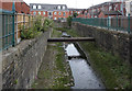
River Croal, Gilnow
The river has been canalised like this for much of its length through Bolton, original for public health reasons.
Image: © Alan Murray-Rust
Taken: 25 Jul 2012
0.06 miles
9
Riverview Walk
The name flatters to deceive - the view of the river looks like this http://www.geograph.org.uk/photo/3079645
Image: © Alan Murray-Rust
Taken: 25 Jul 2012
0.07 miles
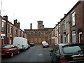
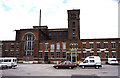
10
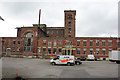
Gilnow Mill - 1
The main front. To the left the roofless engine house, to the right the warehousing and office area. The 4-storey spinning block with its Italianate tower rises behind. The single-storey weaving shed lies behind the warehouse block to the right.
Image: © Alan Murray-Rust
Taken: 25 Jul 2012
0.08 miles