IMAGES TAKEN NEAR TO
Hargreaves Street, BOLTON, BL1 3PD
Introduction
This page details the photographs taken nearby to Hargreaves Street, BL1 3PD by members of the Geograph project.
The Geograph project started in 2005 with the aim of publishing, organising and preserving representative images for every square kilometre of Great Britain, Ireland and the Isle of Man.

There are currently over 7.5m images from over14,400 individuals and you can help contribute to the project by visiting https://www.geograph.org.uk
Image Map
Images are licensed for reuse under creativecommons.org/licenses/by-sa/2.0
Notes
- Clicking on the map will re-center to the selected point.
- The higher the marker number, the further away the image location is from the centre of the postcode.
Image Listing (22 Images Found)
Images are licensed for reuse under creativecommons.org/licenses/by-sa/2.0
Image
Details
Distance
1
Old Toll House by Halliwell Road, Bolton
Toll House, No. 259, Halliwell Road (A6099).
To be surveyed
Milestone Society National ID: MA.BOL02
Image: © Milestone Society
Taken: Unknown
0.04 miles
2
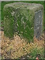
Old Boundary Marker by Boundary Street, Bolton Parish
Parish Boundary Marker by the UC road, in parish of Bolton (Bolton District), Boundary Street, Western end of street on verge, South side of road.
Surveyed
Milestone Society National ID: LA_BOL05pb
Image: © Milestone Society
Taken: Unknown
0.07 miles
3
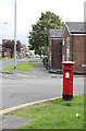
Tennyson Street | Tennyson St / Kenton Close postbox (ref. BL1 302)
Standard EIIR (Post Office) pillar box in a suburban location.
Image: © Alan Murray-Rust
Taken: 25 Jul 2012
0.13 miles
4
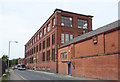
Brownlow Fold Mills - 4
No.3 mill, of 1907, consisted principally of a large weaving shed. The 3-storey section on Tennyson Street seen here would have contained preparation and finishing processes for the weaving section.
Image: © Alan Murray-Rust
Taken: 25 Jul 2012
0.15 miles
5
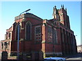
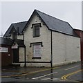
All Souls church
The school building belonging to this church is now an Islamic centre.
Image: © Margaret Clough
Taken: 9 Feb 2006
0.16 miles
6
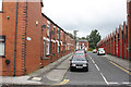
Lytton Street, Brownlow Fold
A reminder of the days when many people lived literally across the road from their place of work.
Image: © Alan Murray-Rust
Taken: 25 Jul 2012
0.16 miles
7
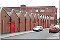
Brownlow Fold Mills - 2
No.3 mill, of 1907, consisted principally of a large weaving shed. The fact that it was latterly a postal sorting office probably explains the red paint.
Image: © Alan Murray-Rust
Taken: 25 Jul 2012
0.16 miles
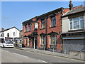
8
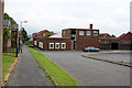
The Roundhouse Pub
Modern pub in a redeveloped area. The name seems incongruous given the rectangular shape, but the partly hidden conical roof gives the necessary clue.
Image: © Alan Murray-Rust
Taken: 25 Jul 2012
0.16 miles
10
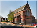
The Parish Church of St Thomas the Apostle, Halliwell
Viewed from Grove Street.
Image: © David Dixon
Taken: 19 Apr 2011
0.17 miles