IMAGES TAKEN NEAR TO
Clarence Street, BOLTON, BL1 2DQ
Introduction
This page details the photographs taken nearby to Clarence Street, BL1 2DQ by members of the Geograph project.
The Geograph project started in 2005 with the aim of publishing, organising and preserving representative images for every square kilometre of Great Britain, Ireland and the Isle of Man.

There are currently over 7.5m images from over14,400 individuals and you can help contribute to the project by visiting https://www.geograph.org.uk
Image Map
Images are licensed for reuse under creativecommons.org/licenses/by-sa/2.0
Notes
- Clicking on the map will re-center to the selected point.
- The higher the marker number, the further away the image location is from the centre of the postcode.
Image Listing (106 Images Found)
Images are licensed for reuse under creativecommons.org/licenses/by-sa/2.0
Image
Details
Distance
1
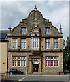
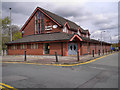
Former school, Clarence Street, Bolton
A striking gabled and pinnacled front, built as St George's School in 1847-48 to the designs of James Greenhalgh, "an architect of some talent". Grade II listed.
Probably now offices.
Image: © Stephen Richards
Taken: 24 Aug 2017
0.01 miles
2
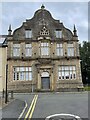
St Georges Boys School, Bolton building
Was a school. Stone carving on the building AD 1847 St George's School. Boy's School.
Image: © Mrs W J Sutherland
Taken: 30 Jun 2024
0.01 miles
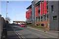
3
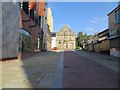
Bath Street, Bolton
On the left is a multi-storey car park. The stone building at the end of the street was originally St. George's School.
Image: © philandju
Taken: 29 Sep 2013
0.02 miles
5
Bethel Evangelical Church, Bolton
The Bethel Church is at the corner of Clarence Street and Palace Street.
Image: © David Dixon
Taken: 27 Apr 2012
0.05 miles
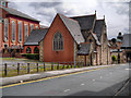
6
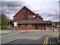
R. C. C. G. Breakthrough Church, Bolton
Before its current use, the building was a craft centre, and before that, St. George's C. of E. Church.
Image: © philandju
Taken: 29 Sep 2013
0.06 miles
7
Former Church (?) on Palace Street
This building on Palace Street looks like it was once a church. There is nothing on it to identify it or its current use; however it does seem to be attached to the adjacent Bolton Centre Holiday Inn hotel (http://www.holidayinn.com/hotels/us/en/bolton/btncc/hoteldetail ) so it may have been incorporated into that.
Image: © David Dixon
Taken: 27 Apr 2012
0.07 miles
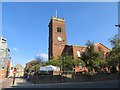
9
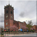
St George's
The Church of Saint George was built in 1796. After closure in the latter half of the twentieth century it was used as a craft centre; the large sign partially obscuring the war memorial reads “St Georges Shops”. It now appears to be empty.
The Church of St George was designated as a Grade II* listed building in 1974 (http://www.britishlistedbuildings.co.uk/en-476250-church-of-st-george-bolton British Listed Buildings).
Image: © David Dixon
Taken: 27 Apr 2012
0.07 miles
10
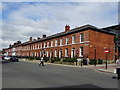
Georgian Terrace
A terrace of nineteen houses, now offices, built circa 1820 and Grade 2 listed.
Image: © philandju
Taken: 12 Jun 2018
0.07 miles