IMAGES TAKEN NEAR TO
Douglas Street, BURY, BL0 9HB
Introduction
This page details the photographs taken nearby to Douglas Street, BL0 9HB by members of the Geograph project.
The Geograph project started in 2005 with the aim of publishing, organising and preserving representative images for every square kilometre of Great Britain, Ireland and the Isle of Man.

There are currently over 7.5m images from over14,400 individuals and you can help contribute to the project by visiting https://www.geograph.org.uk
Image Map (Loading...)


Getting Data...Please wait
Leaflet Map data © OpenStreetMap
Images are licensed for reuse under creativecommons.org/licenses/by-sa/2.0
Notes
- Clicking on the map will re-center to the selected point.
- The higher the marker number, the further away the image location is from the centre of the postcode.
Image Listing (159 Images Found)
Images are licensed for reuse under creativecommons.org/licenses/by-sa/2.0
Image
Details
Distance
1
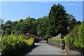
Mount Street Ramsbottom
For the local history of Ramsbottom click on http://web.archive.org/web/20051218151821/http://www.ramsbottom.net/history.htm
Image: © Paul Anderson
Taken: 14 Oct 2006
0.03 miles
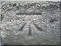
2
Ordnance Survey Cut Mark
This mark can be found on the wall of 286 Dundee Road, Tanners.
Image: © Peter Wood
Taken: 25 Jan 2012
0.04 miles
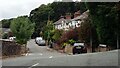
3
Slow on Rawsons Rake, Ramsbottom
A 25% gradient. Slow for vehicles coming down, slow for pedestrians going up.
Image: © Christine Johnstone
Taken: 11 Sep 2021
0.05 miles
4
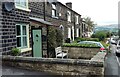
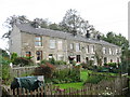
Houses in Tanners Street, Ramsbottom
Built between the mid 1840s and 1890, on the hillside west of the town centre. Lower down the street the original pavement is higher than the modern one.
Image: © Christine Johnstone
Taken: 11 Sep 2021
0.05 miles
5
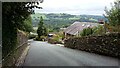
Rawsons Rake
Steep lane leading up to Holcombe Village and the Anglican church. Red signs warn of unsuitability of this road in wintery conditions.
Image: © Chris Heaton
Taken: 10 Jun 2023
0.06 miles
6
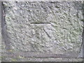
Ordnance Survey Cut Mark
This mark can be found on a building in Tanners Street, Ramsbottom.
Image: © Peter Wood
Taken: 25 Jan 2012
0.06 miles
7
Dundee Lane, Ramsbottom
In the 1840s there was only Dundee House and Dundee School along this lane, which wasn't mapped as 'Dundee Lane' until 1891. There were one or two more homes by 1927, but the houses seen here were built between 1927 and 1939.
Image: © Christine Johnstone
Taken: 11 Sep 2021
0.07 miles
8
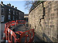
Subsidence on Tanners Street
This large supporting wall at the junction of Tanners Street and Rostron Street in Ramsbottom started to subside in March 2007.
Set back above the wall on top of the embankment are a row of cottages.
As you can see from the picture the stone wall is in danger of collapse after splitting from top to bottom and there is the prospect that this could a major job to put right on what is a busy road at peak times.
Image: © Paul Anderson
Taken: 2 Apr 2007
0.08 miles
9
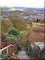
Rawsons Rake, Ramsbottom
Descending steeply towards the town centre in the valley bottom.
Image: © Christine Johnstone
Taken: 11 Sep 2021
0.08 miles
10
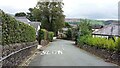
Path to Ramsbottom
Looking down the footpath from Helmshore Road, Holcombe, towards Ramsbottom.
Image: © David Dixon
Taken: 1 Apr 2010
0.08 miles