IMAGES TAKEN NEAR TO
Water Street, BURY, BL0 9GL
Introduction
This page details the photographs taken nearby to Water Street, BL0 9GL by members of the Geograph project.
The Geograph project started in 2005 with the aim of publishing, organising and preserving representative images for every square kilometre of Great Britain, Ireland and the Isle of Man.

There are currently over 7.5m images from over14,400 individuals and you can help contribute to the project by visiting https://www.geograph.org.uk
Image Map (Loading...)


Getting Data...Please wait
Leaflet Map data © OpenStreetMap
Images are licensed for reuse under creativecommons.org/licenses/by-sa/2.0
Notes
- Clicking on the map will re-center to the selected point.
- The higher the marker number, the further away the image location is from the centre of the postcode.
Image Listing (459 Images Found)
Images are licensed for reuse under creativecommons.org/licenses/by-sa/2.0
Image
Details
Distance
1
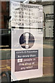
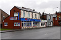
Coronavirus Notice at the Barber Shop
As part of the UK government’s response to the 2020 coronavirus (Covid 19) pandemic https://en.wikipedia.org/wiki/COVID-19_pandemic_in_the_United_Kingdom a “lockdown” was imposed in March, prohibiting all "non-essential" travel and contact with people outside one's home (including family and partners), and shutting almost all schools, business, venues, facilities, amenities and places of worship. This was eased gradually and hairdressers were allowed to resume business on 4 July, allowing many their first haircut for several months. This reopening was conditional and the proprietor was responsible for ensuring that they (and their customers) they followed safety guidelines. This notice was on the window of a barber shop on Water Street. Who could have thought, six months previously, that we would have to give our ‘phone details prior to entering the shop or that we would have to have our temperature checked (a raised temperature being one of the symptoms of Covid 19)?
Image: © David Dixon
Taken: 6 Jul 2020
0.00 miles
2
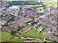
Aerial photograph of Radcliffe
Aerial view looking Southwards at Radcliffe.
At the bottom of the picture the edge of the new (1990s) housing estate can just be seen. Above that are the two primary schools; Gorsefield and St Mary's.
Running diagonally from bottom left to top right (Northeast to Southwest) is the Bury & Bolton Canal. The major Road from right to left (West to East) is Bolton Road, which then turns Southwards becoming first Water Street and then Pilkington Way which passes the Asda Supermarket. At the extreme top left of the picture (South) is Outwood Road, running up the hill towards Outwood and Ringley
Image: © David Dixon
Taken: 14 Aug 2005
0.01 miles
3

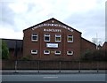
The Lord Raglan, Radcliffe
The pub, on Water Street, was closed in May 2014 (http://www.theboltonnews.co.uk/news/13780814.Troubled_pub_will_not_re_open_following_refusal_of_licence_application/ The Bolton News).
Image: © David Dixon
Taken: 25 Jul 2016
0.01 miles
4
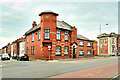
Red Cliff Apartments
This distinctive building was formerly the Lord Raglan public house. It was closed and its licence revoked in 2015 (https://bit.ly/3gwwJdN Bolton News 14 May 2015 https://bit.ly/3fXJL4P Morning Advertiser 25 Nov 2016). It has since been converted to 6 apartments which were completed in 2019.
The pub originally dated from Victorian times, it took its name from Lord Raglan who was Commander in Chief in the British Army during the Crimean War https://en.wikipedia.org/wiki/FitzRoy_Somerset,_1st_Baron_Raglan.
Image: © David Dixon
Taken: 5 Jun 2021
0.01 miles
5
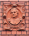
Lord Raglan
Detail on the side of the former Lord Raglan pub (Image]) showing a relief portrait of Lord Raglan who was Commander in Chief in the British Army during the Crimean War https://en.wikipedia.org/wiki/FitzRoy_Somerset,_1st_Baron_Raglan .
Image: © David Dixon
Taken: 5 Jun 2021
0.01 miles
6
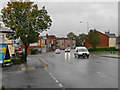
Water Street
A very wet day on Water Street.
Image: © David Dixon
Taken: 30 Sep 2012
0.01 miles
9
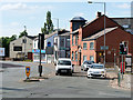
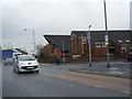
Water Street
The traffic lights at the junction of Water Street (A665) with Spring Lane (A6053).
Image: © David Dixon
Taken: 26 May 2020
0.03 miles