IMAGES TAKEN NEAR TO
Conway Close, BURY, BL0 9EZ
Introduction
This page details the photographs taken nearby to Conway Close, BL0 9EZ by members of the Geograph project.
The Geograph project started in 2005 with the aim of publishing, organising and preserving representative images for every square kilometre of Great Britain, Ireland and the Isle of Man.

There are currently over 7.5m images from over14,400 individuals and you can help contribute to the project by visiting https://www.geograph.org.uk
Image Map (Loading...)


Getting Data...Please wait
Leaflet Map data © OpenStreetMap
Images are licensed for reuse under creativecommons.org/licenses/by-sa/2.0
Notes
- Clicking on the map will re-center to the selected point.
- The higher the marker number, the further away the image location is from the centre of the postcode.
Image Listing (301 Images Found)
Images are licensed for reuse under creativecommons.org/licenses/by-sa/2.0
Image
Details
Distance
1
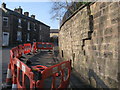
Subsidence on Tanners Street
This large supporting wall at the junction of Tanners Street and Rostron Street in Ramsbottom started to subside in March 2007.
Set back above the wall on top of the embankment are a row of cottages.
As you can see from the picture the stone wall is in danger of collapse after splitting from top to bottom and there is the prospect that this could a major job to put right on what is a busy road at peak times.
Image: © Paul Anderson
Taken: 2 Apr 2007
0.03 miles
2
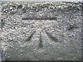
Ordnance Survey Cut Mark
This mark can be found on a building in Tanners Street, Ramsbottom.
Image: © Peter Wood
Taken: 25 Jan 2012
0.03 miles
3
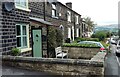
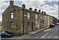
Houses in Tanners Street, Ramsbottom
Built between the mid 1840s and 1890, on the hillside west of the town centre. Lower down the street the original pavement is higher than the modern one.
Image: © Christine Johnstone
Taken: 11 Sep 2021
0.03 miles
4

Narrow houses near Holcombe
Stone cottages in Tanners Street.
Image: © philandju
Taken: 11 Jul 2012
0.03 miles
5
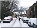
Rostron Road Ramsbottom
Local residents are pictured here on Rostron Road in Ramsbottom clearing the road and putting grit down after heavy snowfall earlier in the day.
The local Bury Metropolitan Borough Council have a policy of not gritting side streets resulting in steep inclined roads such as this becoming impassable but for the efforts of the local community.
Image: © Paul Anderson
Taken: 21 Dec 2009
0.05 miles
6
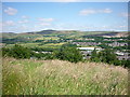
Scout Moor wind farm
Taken from Rake Fold, Holcombe, Lancashire, I am looking north east to Scout and Knowl Moors and the wind farm spreading across from one to the other. Fletcher Bank quarry is to right of shot; Ramsbottom lies in the valley immediately below.
Image: © Carroll Pierce
Taken: 15 Jul 2015
0.06 miles
7

WWII Lancashire: Ghost Signs of the Home Front (20)
-
Emergency Rendezvous Point, Rostron Road, Ramsbottom, at junction with Victoria Street
"ERP 438" looks remarkably fresh, I wonder if it has been enhanced?
Emergency Rendezvous Points (ERP) were designated places in the locality for the coordination of ARP and emergency services during civil emergencies, particularly for those services arriving from outside the area. The signs appear in a variety of designs, but most are diamond shapes framing the ERP locality number.
Image
Image: © Mike Searle
Taken: 13 Aug 2021
0.07 miles
8
WWII Lancashire: Ghost Signs of the Home Front (21)
-
Emergency Rendezvous Point, Rostron Road, Ramsbottom, at junction with Victoria Street
"ERP 438"
Emergency Rendezvous Points (ERP) were designated places in the locality for the coordination of ARP and emergency services during civil emergencies, particularly for those services arriving from outside the area. The signs appear in a variety of designs, but most are diamond shapes framing the ERP locality number.
Image
Image: © Mike Searle
Taken: 13 Aug 2021
0.07 miles
9

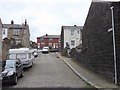
Back passage off Rostron Road
The passage runs between Victoria Street and Albert Street. Victoria is the higher one, as illustrated by the sheds perched on the top of the wall to the right.
Image: © Bill Boaden
Taken: 11 Dec 2016
0.07 miles
10
Vesta Street, Off Albert Street, Ramsbottom
Image: © Robert Wade
Taken: 19 Jul 2011
0.07 miles