IMAGES TAKEN NEAR TO
Kay Brow, BURY, BL0 9AY
Introduction
This page details the photographs taken nearby to Kay Brow, BL0 9AY by members of the Geograph project.
The Geograph project started in 2005 with the aim of publishing, organising and preserving representative images for every square kilometre of Great Britain, Ireland and the Isle of Man.

There are currently over 7.5m images from over14,400 individuals and you can help contribute to the project by visiting https://www.geograph.org.uk
Image Map
Images are licensed for reuse under creativecommons.org/licenses/by-sa/2.0
Notes
- Clicking on the map will re-center to the selected point.
- The higher the marker number, the further away the image location is from the centre of the postcode.
Image Listing (654 Images Found)
Images are licensed for reuse under creativecommons.org/licenses/by-sa/2.0
Image
Details
Distance
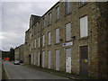
1
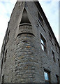
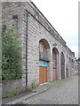
Cobden Mill, Ramsbottom
This old cotton mill has now been converted into apartments. It is situated at the corner of Square Street and Kay Brow.
Image: © michael ely
Taken: 23 Nov 2010
0.03 miles
2
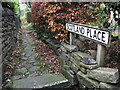
Scotland Place, Ramsbottom
This is a narrow entrance to a row of cottages off Square Street just north of Cobden Mill.
Image: © michael ely
Taken: 23 Nov 2010
0.03 miles
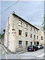
3
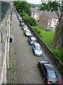
Lodge Street Ramsbottom
The cobbled street of Lodge Street runs parallel with Bolton Street in the centre of Ramsbottom.
During the evening and at weekends parking in this area is at a premium as can be seen by the number of cars in the picture.
Compare this photograph with Image which was taken during the week in the middle of the day.
For more on the history of Ramsbottom click on http://www.ramsbottom.net/history.htm
Image: © Paul Anderson
Taken: 23 May 2009
0.04 miles
4
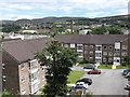
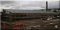
Kay Brow flats-apartments from Verna Street, Ramsbottom
Scout Moor windfarm on the horizon
Image: © Robert Wade
Taken: 26 Jun 2011
0.04 miles
6
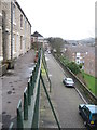
Lodge Street Ramsbottom
The row of houses on the left are on Verna Street which is situated in an elevated position above the cobbled Lodge Street below.
For more on the history of Ramsbottom click on http://web.archive.org/web/20051218151821/http://www.ramsbottom.net/history.htm
Image: © Paul Anderson
Taken: 5 Mar 2007
0.04 miles
7
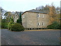
Converted Flats Barley Lea Mill
Converted Flats in Ramsbottom
Image: © David Walton
Taken: 14 Nov 2007
0.04 miles
9
Lodge Street-Verna Street, Ramsbottom, Lancashire
Image: © Robert Wade
Taken: 13 Aug 2011
0.04 miles
10
Cobden Mill
Part of the mill has been converted into flats
Image: © Alexander P Kapp
Taken: 18 May 2007
0.05 miles