IMAGES TAKEN NEAR TO
Central Street, BURY, BL0 9AF
Introduction
This page details the photographs taken nearby to Central Street, BL0 9AF by members of the Geograph project.
The Geograph project started in 2005 with the aim of publishing, organising and preserving representative images for every square kilometre of Great Britain, Ireland and the Isle of Man.

There are currently over 7.5m images from over14,400 individuals and you can help contribute to the project by visiting https://www.geograph.org.uk
Image Map
Images are licensed for reuse under creativecommons.org/licenses/by-sa/2.0
Notes
- Clicking on the map will re-center to the selected point.
- The higher the marker number, the further away the image location is from the centre of the postcode.
Image Listing (663 Images Found)
Images are licensed for reuse under creativecommons.org/licenses/by-sa/2.0
Image
Details
Distance
1
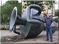
Watering Hole
Interesting feature in Ramsbottom town centre.
Image: © Roger May
Taken: 26 Aug 2001
0.01 miles
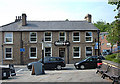
2
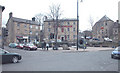
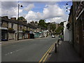
Market Place
At the junction of Bolton Street (A676) and Bridge Street. To the right of centre is a sculpture http://www.geograph.org.uk/photo/39314 from the Irwell Sculpture Trail. The Civic Hall is to the right of the picture.
Image: © Dennis Turner
Taken: 20 Mar 2006
0.01 miles
3
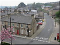
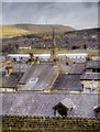
Central Street Ramsbottom
Looking down Central Street in Ramsbottom from the top of Image
For more about the history of Ramsbottom click on http://web.archive.org/web/20051218151821/http://www.ramsbottom.net/history.htm
Image: © Paul Anderson
Taken: 21 Apr 2007
0.01 miles
4
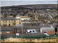
Rooftops of Ramsbottom
A view over the village/town of Ramsbottom, looking from Callender Street. The most dominant feature is the spire of Image] although some of the turbines of the Scout Moor Wind Farm (Image]) can also be seen on the hill opposite.
Image: © David Dixon
Taken: 2 Mar 2015
0.02 miles
5
Ramsbottom
A view looking over the village/town of Ramsbottom from Callender Street. The most prominent feature is the tower and spire of Image] in the centre of the village. The turbines of the Scout Moor Wind Farm (Image]) dominate the skyline on the hill on the opposite side of the valley.
Image: © David Dixon
Taken: 2 Mar 2015
0.02 miles
8
Blue Plaque "Peter Murray McDouall 1814-1854" Greenlees Roger (Jewellers) 18 Bolton Street, Ramsbottom BL0 9HX
Image: © Robert Wade
Taken: 26 Jun 2011
0.02 miles
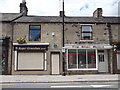
10
Chocolate Cafe, Ramsbottom
Opposite Market Place on the corner of Carr Street and Bolton Street. It opened just over a week ago and is nicely refurbished inside.
Image: © michael ely
Taken: 23 May 2008
0.02 miles