IMAGES TAKEN NEAR TO
Fecit Lane, BURY, BL0 0RP
Introduction
This page details the photographs taken nearby to Fecit Lane, BL0 0RP by members of the Geograph project.
The Geograph project started in 2005 with the aim of publishing, organising and preserving representative images for every square kilometre of Great Britain, Ireland and the Isle of Man.

There are currently over 7.5m images from over14,400 individuals and you can help contribute to the project by visiting https://www.geograph.org.uk
Image Map
Images are licensed for reuse under creativecommons.org/licenses/by-sa/2.0
Notes
- Clicking on the map will re-center to the selected point.
- The higher the marker number, the further away the image location is from the centre of the postcode.
Image Listing (14 Images Found)
Images are licensed for reuse under creativecommons.org/licenses/by-sa/2.0
Image
Details
Distance
1

Fecit Farm with Fecit End Delf behind
Fecit End Delf is a disused quarry on the edge of the Scout Moor escarpment. The dark band running down the edge of the hill and continuing off the left hand side of the picture is waste stone tipped from the quarry.
Image: © Mike Lee
Taken: 12 Jul 2003
0.00 miles
2

Fecit Farm
It sits on a hillside with views to Holcombe Moor and Ramsbottom.
Image: © Bill Boaden
Taken: 24 Jun 2009
0.01 miles
3
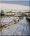
Fecit Farm
Just off the main A680 Rochdale Road Fecit Farm is located at the top of
this single track snow covered lane.
No longer a working farm it is now divided into private dwellings
Image
Image: © Paul Anderson
Taken: 2 Dec 2008
0.05 miles
4
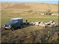
Feeding Time
A farmer tends to his sheep just below Fecit Farm next to the A680 Rochdale Road.
Image: © Paul Anderson
Taken: 18 Feb 2008
0.07 miles
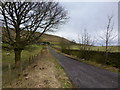
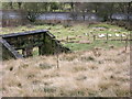
6

11kV power line to Fecit Farm and Bungalow
The ruined building is the remains of Dungeon Farm.
Image: © Mike Lee
Taken: 30 Jul 2007
0.09 miles
7
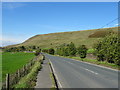
Rochdale Road (A680) towards Edenfield
Looking north west.
Image: © JThomas
Taken: 25 Sep 2018
0.13 miles
10
Remains of Dungeon Farm
A680 Rochdale Road seen behind
Image: © liz dawson
Taken: 31 Dec 2007
0.21 miles