IMAGES TAKEN NEAR TO
North View, BURY, BL0 0NX
Introduction
This page details the photographs taken nearby to North View, BL0 0NX by members of the Geograph project.
The Geograph project started in 2005 with the aim of publishing, organising and preserving representative images for every square kilometre of Great Britain, Ireland and the Isle of Man.

There are currently over 7.5m images from over14,400 individuals and you can help contribute to the project by visiting https://www.geograph.org.uk
Image Map
Images are licensed for reuse under creativecommons.org/licenses/by-sa/2.0
Notes
- Clicking on the map will re-center to the selected point.
- The higher the marker number, the further away the image location is from the centre of the postcode.
Image Listing (120 Images Found)
Images are licensed for reuse under creativecommons.org/licenses/by-sa/2.0
Image
Details
Distance
1
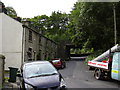
South Terrace and Strongstry Road
Seen from a northbound East Lancs Railway train on Strongstry Bridge.
Image: © Christine Johnstone
Taken: 6 Sep 2018
0.01 miles
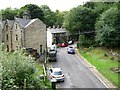
2
North View with South Terrace in the background
Image: © Alexander P Kapp
Taken: 31 Mar 2009
0.02 miles
3
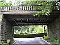
Disused railway bridge
Use to carried the now dismantled Accington to Ramsbottom Railway
Image: © Alexander P Kapp
Taken: 31 Mar 2009
0.02 miles
4
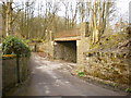
Disused railway bridge
On Stubbins Vale Road, the railway line was the Accrington to Ramsbottom line
Image: © Alexander P Kapp
Taken: 31 Mar 2009
0.02 miles
6
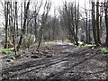
Abandoned Clifton Junction to Accrington Railway Line
At this point, just before Strongstry bridge the cycle way leaves the old track bed, the ELR track is to the left of this photo
Image: © Robert Wade
Taken: 18 Mar 2011
0.02 miles
7
Strongstry Bridge on the Clifton Junction to Accrington Railway Line
Fenced off but I'm sure it could carry the weight of a couple of bicycles !
Image: © Robert Wade
Taken: 18 Mar 2011
0.02 miles
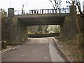
8
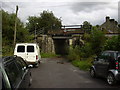
ELR Bridge
The East Lancashire Railway, a preserved line, runs from Bury to Rawtenstall.
Image: © Robert Wade
Taken: 11 Sep 2008
0.02 miles
9
North View, Strongstry
The disused railway bridge carried the line from Ramsbottom to Helmshore.
Image: © Robert Wade
Taken: 11 Sep 2008
0.03 miles
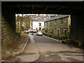
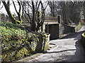
10
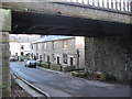
North View Cottages Strongstry
Not far from Stubbins is the hamlet of Strongstry. Like their neighbour they both have medieval origins. Most of the houses in present day Strongstry date from the 19th century and were built by the Porritts to house their mill workers.
The only vehicular access to Strongstry is via the low 10ft 6in bridge in the picture which once was a branch line from Stubbins to Accrington Image
Image: © Paul Anderson
Taken: 25 Jan 2007
0.03 miles