IMAGES TAKEN NEAR TO
Market Street, BURY, BL0 0HL
Introduction
This page details the photographs taken nearby to Market Street, BL0 0HL by members of the Geograph project.
The Geograph project started in 2005 with the aim of publishing, organising and preserving representative images for every square kilometre of Great Britain, Ireland and the Isle of Man.

There are currently over 7.5m images from over14,400 individuals and you can help contribute to the project by visiting https://www.geograph.org.uk
Image Map
Images are licensed for reuse under creativecommons.org/licenses/by-sa/2.0
Notes
- Clicking on the map will re-center to the selected point.
- The higher the marker number, the further away the image location is from the centre of the postcode.
Image Listing (86 Images Found)
Images are licensed for reuse under creativecommons.org/licenses/by-sa/2.0
Image
Details
Distance
1
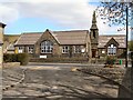
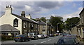
Edenfield Primary School
Market Street Edenfield.
Image: © David Dixon
Taken: 15 Apr 2010
0.00 miles
3
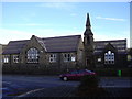
Edenfield School
Primary School in Edenfield.
Image: © Wayland Smith
Taken: 2 Jul 2011
0.01 miles
4
Market Street, Edenfield
Market Street, Edenfield at the junction of Burnley Road and Blackburn Road on the site of Finger Post garage. The school is just out of shot on the left.
Image: © Mark Trickett
Taken: 25 Jul 2005
0.02 miles
5
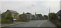
Market Street Edenfield
Looking towards the fingerpost traffic lights where the road divides into Burnley and Blackburn Road. The A56 Edenfield Bypass replaced this once important route.
Image: © Robert Wade
Taken: 19 Jul 2007
0.02 miles
6
East Street Edenfield
This is the junction of the narrow East Street as it opens up on to Market Street in Edenfield.
Image] is across the road.
Image: © Paul Anderson
Taken: 8 Mar 2007
0.02 miles
7
"Fingerpost" Junction, Edenfield
From Blackburn Road
Image: © Robert Wade
Taken: 4 Jun 2010
0.02 miles
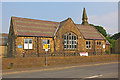
8
Edenfield Primary School
Edenfield Primary School is located to the north of the village on Market Street.
Much of the land in the area is in the ownership of the National Trust, the result of a bequest by the Porritt family in memory of Richard Porritt, the first Member of Parliament to be killed in action during the Second World War, and many attractive footpaths traverse this area, including a section of the 45-mile Rossendale Way long-distance footpath.
The population of this area of the Borough is approximately 3,500 and, although mainly of a residential nature, a number of light industries are carried out in the area.
Edenfield Primary School Web Site click on http://www.edenfieldceprimary.ik.org/
Image: © Paul Anderson
Taken: 26 Jan 2007
0.03 miles
9
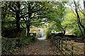
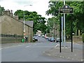
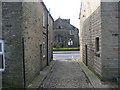
Access Lane heading for Market Street in Edenfield
Heading onto the B6527 in Edenfield, opposite the parish church.
Image: © Chris Heaton
Taken: 8 Oct 2017
0.03 miles
10
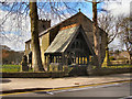
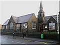
Edenfield Parish Church
Market Street.
Image: © David Dixon
Taken: 15 Apr 2010
0.03 miles