IMAGES TAKEN NEAR TO
Fletcher Bank, BURY, BL0 0DD
Introduction
This page details the photographs taken nearby to Fletcher Bank, BL0 0DD by members of the Geograph project.
The Geograph project started in 2005 with the aim of publishing, organising and preserving representative images for every square kilometre of Great Britain, Ireland and the Isle of Man.

There are currently over 7.5m images from over14,400 individuals and you can help contribute to the project by visiting https://www.geograph.org.uk
Image Map
Images are licensed for reuse under creativecommons.org/licenses/by-sa/2.0
Notes
- Clicking on the map will re-center to the selected point.
- The higher the marker number, the further away the image location is from the centre of the postcode.
Image Listing (55 Images Found)
Images are licensed for reuse under creativecommons.org/licenses/by-sa/2.0
Image
Details
Distance
1
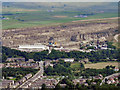
Fletcher Bank Quarry, Ramsbottom
Fletcher Bank Quarry at Ramsbottom, viewed from the top of the Peel Monument.
Image: © David Dixon
Taken: 15 Aug 2010
0.09 miles
3

Shuttleworth: The 'Eagle and Child'
On the A56
Image: © Dr Neil Clifton
Taken: 4 Jun 2013
0.10 miles
4
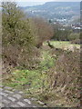
Whitelow Road
This is an ancient by-way that now links the A56 with Bury Old Road. The surface is quite good at the top, but here, near the junction with the A56, there are many loose stones caused by water erosion.
Image: © michael ely
Taken: 25 Jul 2008
0.10 miles
6
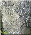
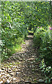
OS Cut Mark - Ramsbottom, Whitelow Road Right of Way
https://www.bench-marks.org.uk/bm94166
Image: © thejackrustles
Taken: 17 Jul 2022
0.10 miles
7
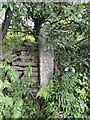
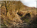
Location of OS Cut Mark - Ramsbottom, Whitelow Road Right of Way
Image: © thejackrustles
Taken: 17 Jul 2022
0.11 miles
8
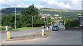
Bury New Road Junction
Looking west towards Ramsbottom the road opposite is Bury New Road with the main A56 Manchester Road running through the junction from left to right.
Image: © Paul Anderson
Taken: 8 Aug 2008
0.11 miles
9
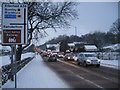
Manchester Road Ramsbottom
This is the A56 Manchester Road seen here after a night of heavy snow.
The A56 runs parallel with the nearby M66 motorway and is the main diversion route when the motorway is closed
which is signified by the black diamond on the road sign in the picture.
Image
Image: © Paul Anderson
Taken: 2 Feb 2009
0.11 miles
10

Shuttleworth: The 'Eagle and Child'
On the A56.
Image: © Dr Neil Clifton
Taken: 4 Jun 2013
0.11 miles