IMAGES TAKEN NEAR TO
Bury New Road, BURY, BL0 0AR
Introduction
This page details the photographs taken nearby to Bury New Road, BL0 0AR by members of the Geograph project.
The Geograph project started in 2005 with the aim of publishing, organising and preserving representative images for every square kilometre of Great Britain, Ireland and the Isle of Man.

There are currently over 7.5m images from over14,400 individuals and you can help contribute to the project by visiting https://www.geograph.org.uk
Image Map
Images are licensed for reuse under creativecommons.org/licenses/by-sa/2.0
Notes
- Clicking on the map will re-center to the selected point.
- The higher the marker number, the further away the image location is from the centre of the postcode.
Image Listing (369 Images Found)
Images are licensed for reuse under creativecommons.org/licenses/by-sa/2.0
Image
Details
Distance
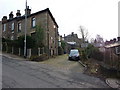
2
South Street, Ramsbottom
This back lane runs down the rear of houses on Peel Brow.
Image
The church spire in the picture is
Image
Image: © Paul Anderson
Taken: 8 Aug 2008
0.04 miles
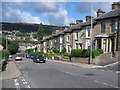
3
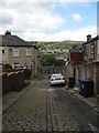
South Street
Back street to Peel Brow showing the original sets in the roadway.
Image: © John Tomlinson
Taken: 11 Jun 2009
0.05 miles
4
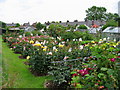
Peel Brow Allotments
These allotments,just off South Street,are located just yards from the M66 Motorway in Ramsbottom.
In 1915 George Henry Cheshire was the prime mover in getting together the local people to form the allotment grounds as we see them today.
Image: © Paul Anderson
Taken: 19 Jun 2007
0.06 miles
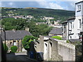
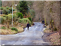
6
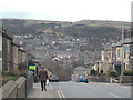
Peel Brow
View looking due west from Peel Brow, one of the main routes into and out of Ramsbottom, until the easier gradient of nearby Bury New Road was built.
Image: © Dennis Turner
Taken: 20 Mar 2006
0.07 miles
7
Peel Brow view
Looking west from Peel Brow across the town towards Holcombe Hill.
Image: © Dennis Turner
Taken: 20 Mar 2006
0.07 miles
8
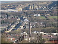
Ramsbottom
Image is the road to going up the left of the picture and Imagedominates the sky line above Ramsbottom.
The mill chimney in the centre is Image
Picture taken with zoom lens near to Image on the west side of the valley.
For the history of Ramsbottom click on http://web.archive.org/web/20051218151821/http://www.ramsbottom.net/history.htm
Image: © Paul Anderson
Taken: 14 Jan 2007
0.07 miles
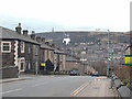
10
Peel Brow Ramsbottom
Peel Brow is a steep hill that links Bury New Road in Ramsbottom
at the bottom with Whalley Road in Shuttleworth at the top.
Image
Image: © Paul Anderson
Taken: 8 Aug 2008
0.08 miles