IMAGES TAKEN NEAR TO
Sandringham Gardens, BOURNEMOUTH, BH9 3QW
Introduction
This page details the photographs taken nearby to Sandringham Gardens, BH9 3QW by members of the Geograph project.
The Geograph project started in 2005 with the aim of publishing, organising and preserving representative images for every square kilometre of Great Britain, Ireland and the Isle of Man.

There are currently over 7.5m images from over14,400 individuals and you can help contribute to the project by visiting https://www.geograph.org.uk
Image Map
Images are licensed for reuse under creativecommons.org/licenses/by-sa/2.0
Notes
- Clicking on the map will re-center to the selected point.
- The higher the marker number, the further away the image location is from the centre of the postcode.
Image Listing (82 Images Found)
Images are licensed for reuse under creativecommons.org/licenses/by-sa/2.0
Image
Details
Distance
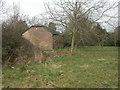
1
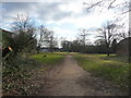
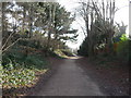
Bournemouth : Muscliff - Footpath
This path heads towards the car park where people can come a walk their dog along the River Stour.
Image: © Lewis Clarke
Taken: 11 Feb 2010
0.04 miles
2
Muscliff: steps onto footpath M15
Looking up the course of the public footpath to Granby Road, up the slope to the right, while steps from the Kingfisher Barn information centre join from the left.
This is photo 40 in a series of 43 along the length of public footpath M15, Bournemouth's longest public right of way and the only one over 2km in length. It forms part of the Stour Valley Way long-distance path, although it doesn't see all that much of the Stour. It consists of a tarmacked lane at the Throop end and a good quality gravel path for the majority of its course - it has been improved in the last few years to make it wheelchair accessible and a shared route for cyclists. See Image for the previous photo and Image for the next - these provide links to the other photos all along the route to each end.
Image: © Chris Downer
Taken: 16 Jul 2016
0.05 miles
3
Bournemouth : Muscliff - Footpath & House
An open area near the car park and River Stour riverside path.
Image: © Lewis Clarke
Taken: 11 Feb 2010
0.05 miles
4
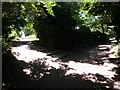
Muscliff: descending to the river on footpath M15
Looking down this public footpath, under an intensely dappled light thanks to tree cover, as a distant silhouette approaches the riverbank.
This is photo 39 in a series of 43 along the length of public footpath M15, Bournemouth's longest public right of way and the only one over 2km in length. It forms part of the Stour Valley Way long-distance path, although it doesn't see all that much of the Stour. It consists of a tarmacked lane at the Throop end and a good quality gravel path for the majority of its course - it has been improved in the last few years to make it wheelchair accessible and a shared route for cyclists. See Image for the previous photo and Image for the next - these provide links to the other photos all along the route to each end.
Image: © Chris Downer
Taken: 16 Jul 2016
0.05 miles
5
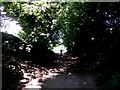
Bournemouth : Footpath
A footpath from the river to the nearby car park.
Image: © Lewis Clarke
Taken: 11 Feb 2010
0.05 miles
6
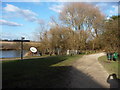
Bournemouth : The River Stour, Signpost & Information Display
The display has a lot of information for those who like ornithology.
Image: © Lewis Clarke
Taken: 11 Feb 2010
0.06 miles
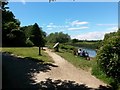
7
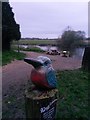
Muscliff: a kingfisher points to the caf
This kingfisher is the basis of a signpost to the café and visitor centre of the Kingfisher Barn, a short distance behind us. He must have been installed in the last two years, as he stands on the near corner of the grass triangle in this July 2016 photo: Image
It is close to dusk as we look over the River Stour in the background, with the riverside path heading in both directions.
Image: © Chris Downer
Taken: 17 Apr 2018
0.06 miles
8
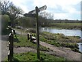
Muscliff: Stour Valley Way
This signpost guides the way along the Stour Valley Way, towards Redhill and Dudsbury ahead, and towards Throop mill, behind the camera.
Image: © Chris Downer
Taken: 23 Mar 2008
0.06 miles
9
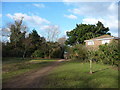
Muscliff, converted barn
Now headquarters of the rangers at Stour Valley Nature Reserve http://www.bournemouth.gov.uk/Visitors/Parks_Gardens_Countryside/Stour_valley/Stour_Valley_Local_Nature_Reserve.asp
Image: © Mike Faherty
Taken: 1 Mar 2009
0.06 miles
10
Muscliff: the Stour Valley Way and footpath M15 part
This is one of the few points in the immediate vicinity where the Stour Valley Way runs directly alongside the river. Meanwhile, the route of the public right of way, footpath M15, leaves the route of the Stour Valley Way and heads to the left.
This is photo 36 in a series of 43 along the length of public footpath M15, Bournemouth's longest public right of way and the only one over 2km in length. It forms part of the Stour Valley Way long-distance path, although it doesn't see all that much of the Stour. It consists of a tarmacked lane at the Throop end and a good quality gravel path for the majority of its course - it has been improved in the last few years to make it wheelchair accessible and a shared route for cyclists. See Image for the previous photo and Image for the next - these provide links to the other photos all along the route to each end.
Image: © Chris Downer
Taken: 16 Jul 2016
0.06 miles