1
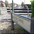
Muscliff: Newmorton Road
Part of a small development of bungalows on this western side of Muscliffe Lane.
The slightly leaning sign is the standard Bournemouth nameplate from the 1980s, affixed with tubular steel which protrudes at each side.
This is photo no.291 of a series of 453 in my coronavirus lockdown walking project:
See https://www.geograph.org.uk/article/My-2020-Coronavirus-Lockdown-walking-project for the complete set of photos.
Image: © Chris Downer
Taken: 10 Apr 2020
0.03 miles
2
Stour Valley Nature Reserve
This is the entrance to the reserve with the information board in the foreground.
Image: © Stuart Buchan
Taken: 13 Oct 2005
0.08 miles
3
Bournemouth : Muscliff - Muscliffe Lane
Muscliffe Lane taken on the junction with Strathmore Road.
Image: © Lewis Clarke
Taken: 11 Feb 2010
0.08 miles
4
Bournemouth : Muscliffe Lane & Postbox
A postbox and bus stop on Muscliffe Lane
Image: © Lewis Clarke
Taken: 6 Jun 2008
0.08 miles
5
Bournemouth : Muscliff - Muscliff Lane Bus Shelter
I'm sure there used to be glass where that big X is - unless it's just an advert for Britain's Got Talent.
Image: © Lewis Clarke
Taken: 11 Feb 2010
0.09 miles
6
Bournemouth : Muscliff - Castle Lane West Pedestrian Crossing
When you cross the road you can go and have some pizza in the Pizza Hut if you wanted to.
Image: © Lewis Clarke
Taken: 11 Feb 2010
0.09 miles
7
Muscliff: Muscliffe Lane
Notwithstanding the labelling of the Ordnance Survey's maps, the suburb of Muscliff rightly does not have an 'e' on the end, although it did develop over the second half of the 20th century and it stuck in the name of Muscliffe Lane, which we see here from its start on the busy A3060 Castle Lane West.
The bench faces a service road for a parade of shops on Castle Lane West.
The sign is an early version of a standard Bournemouth design from around 2000, the early version recognisable by a slightly more emboldened typeface, aligned to the left when on two lines: Shorter names lead to a large gap on the right-hand side of the sign (Owls Road in Boscombe is the champion in this respect), so perhaps that is why the centred text evolved.
This is photo no.287 of a series of 453 in my coronavirus lockdown walking project:
See Link for the complete set of photos.
Image: © Chris Downer
Taken: 10 Apr 2020
0.09 miles
8
Redhill: Castle Lane West
Castle Lane West and East from the A3060, a very busy road through the northern suburbs of Bournemouth. All is very quiet here, however, not just because we are in the midst of the coronavirus lockdown but also because it's a couple of minutes past 7 o'clock on Easter Sunday morning.
The road sign is a standard borough 1980s one, which must have been retained and reused on this railing because this junction was reconfigured in the early 90s, having previously been a mini-roundabout.
This is photo no.63 of a series of 453 in my coronavirus lockdown walking project:
See https://www.geograph.org.uk/article/My-2020-Coronavirus-Lockdown-walking-project for the complete set of photos.
Image: © Chris Downer
Taken: 12 Apr 2020
0.09 miles
9
Redhill: riverside bench
A place to rest and take in the views of the River Stour, as it heads towards Christchurch Harbour over the northern side of Bournemouth.
Rather oddly, this bench is in Christchurch despite being Bournemouth side of the river: the boundary at this point is not the river itself but strays south for a short distance.
Image: © Chris Downer
Taken: 23 Mar 2008
0.09 miles
10
Muscliff: postbox № BH9 263, Muscliffe Lane
Here, we look northeast along Muscliffe Lane, past this George VI-reign postbox on the corner of Strathmore Road.
Image: © Chris Downer
Taken: 18 Jul 2008
0.09 miles


