IMAGES TAKEN NEAR TO
Priory View Road, BOURNEMOUTH, BH9 3JQ
Introduction
This page details the photographs taken nearby to Priory View Road, BH9 3JQ by members of the Geograph project.
The Geograph project started in 2005 with the aim of publishing, organising and preserving representative images for every square kilometre of Great Britain, Ireland and the Isle of Man.

There are currently over 7.5m images from over14,400 individuals and you can help contribute to the project by visiting https://www.geograph.org.uk
Image Map (Loading...)


Getting Data...Please wait
Leaflet Map data © OpenStreetMap
Images are licensed for reuse under creativecommons.org/licenses/by-sa/2.0
Notes
- Clicking on the map will re-center to the selected point.
- The higher the marker number, the further away the image location is from the centre of the postcode.
Image Listing (88 Images Found)
Images are licensed for reuse under creativecommons.org/licenses/by-sa/2.0
Image
Details
Distance
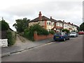
1
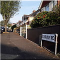
Moordown: Cobham Road
Cobham Road is a short side-road in the north of Moordown, characterised like the surrounding area by desirable detached houses.
The sign is the standard Bournemouth nameplate from the 1980s, affixed with tubular steel which protrudes at each side.
This is photo no.73 of a series of 453 in my coronavirus lockdown walking project:
See https://www.geograph.org.uk/article/My-2020-Coronavirus-Lockdown-walking-project for the complete set of photos.
Image: © Chris Downer
Taken: 12 Apr 2020
0.05 miles
3
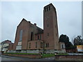
Bournemouth : Muscliff - Parish Church of the Holy Epiphany
Image: © Lewis Clarke
Taken: 27 Apr 2009
0.06 miles
4
Muscliff: parish church of the Holy Epiphany
Although the name is often seen with an E on the end (as in nearby Muscliffe Lane and Muscliffe Road), it is traditionally without it.
Image: © Chris Downer
Taken: Unknown
0.07 miles
5
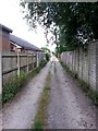
Moordown: Priory View Place leaves Redbreast Road North
Priory View Place is essentially a rear access lane to shops on Castle Lane West, between Priory View Road and Redbreast Road North, but it does have a couple of residential properties along it. It also forms public footpath M12. Here, we look along it from the Redbreast end.
See Image for the view towards us from a little way along the lane, and links to further views along the route.
Image: © Chris Downer
Taken: 10 Jul 2016
0.07 miles
6
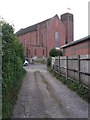
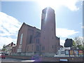
Moordown: western end of Priory View Place
Priory View Place is essentially a rear access lane to shops on Castle Lane West, between Priory View Road and Redbreast Road North, but it does have a couple of residential properties along it. It also forms public footpath M12.
Here, we look towards its western end, onto Redbreast Road North, with the Epiphany parish church looming large over us opposite.
See Image for the view towards us from the road ahead, and Image for the next view along the lane behind us, with links to further views along the route.
Image: © Chris Downer
Taken: 10 Jul 2016
0.08 miles
9
Moordown: Priory View Place heads east
Priory View Place is essentially a rear access lane to shops on Castle Lane West, between Priory View Road and Redbreast Road North, but it does have a couple of residential properties along it. It also forms public footpath M12.
Here, we look eastward from a short way in from the Redbreast end.
See Image for the next view along the lane ahead, and Image for the next view behind us, each with links to further views along the route.
Image: © Chris Downer
Taken: 10 Jul 2016
0.09 miles
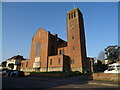
10
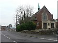
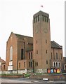
Moordown: former Congregational Church
This church stands at the top of Priory View Road (which descends to the left of the picture and from here does indeed offer fine views across to Christchurch). It has lain unused for several years.
Image: © Chris Downer
Taken: 24 Feb 2008
0.09 miles