1
Ensbury Park: snow equals traffic jams
Overnight snow fall which continues into this morning's rush hour makes the term 'rush hour' something of an insult. If the school's hadn't already broken up for the Christmas holiday it would have been even worse!
We look out of the car while sat at a red light, as traffic crawls around the Ensbury Park gyratory system. The bungalows of Oswald Road look pretty in the background.
Image: © Chris Downer
Taken: 20 Dec 2010
0.03 miles
2
Winton: Oswald Close and Road on St. Oswald?s Day
Oswald Close comes out onto Oswald Road at the point where the latter becomes two-way, meaning that it is only possible to turn right from here. The bungalows facing us are typical of the area, although all sorts of housing is peppered around the surrounding streets.
This picture is taken on St. Oswald's Day which, being on 29 February, only occurs once in four years.
Image: © Chris Downer
Taken: 29 Feb 2012
0.03 miles
3
Redhill: Redhill Park Fire Station
For discussion on the snowy scene, see
Image
Image: © Chris Downer
Taken: 25 Dec 2007
0.05 miles
4
Winton: Oswald Road on St. Oswald?s Day
The highest numbered bungalows in Oswald Road, almost facing the fire station at Redhill Park. The picture was taken on St. Oswald's Day, which comes but once every four years, being on 29 February.
Image: © Chris Downer
Taken: 29 Feb 2012
0.06 miles
5
Bournemouth : Cherries Drive
The back end of the fire station on Cherries Drive.
Image: © Lewis Clarke
Taken: 11 Feb 2010
0.06 miles
6
Redhill: white Christmas, 2007
A very localised cold snap and snowfall produced this wintry scene on Christmas morning of 2007. It was so localised, in fact, that it only encompassed the fire station at Redhill Park and its curtilage. Elsewhere, the area was several degrees above freezing and engulfed in a horrid drizzle.
Conspiracy theorists might have you believe that this was actually artificial snow, but I prefer to believe it was real snow.
Image: © Chris Downer
Taken: 25 Dec 2007
0.06 miles
7
Bournemouth : Redhill Park Fire Station
Looking at the fire station from behind the front on Cherries Drive.
Image: © Lewis Clarke
Taken: 11 Feb 2010
0.07 miles
8
Redhill Park Fire Station
Fire station with distinctive tower at the junction of Redhill Avenue & Cherries Drive; the coat of arms above the main entrance is that of Bournemouth, so the building presumably dates to times when Bournemouth had its own fire service. Now operated by Dorset Fire & Rescue Service http://www.dorsetfire.co.uk/index.php?ref=142
Image: © Mike Faherty
Taken: 26 Jul 2009
0.07 miles
9
Redhill Park Fire Station
Redhill Park Fire Station, Redhill Avenue, Bournemouth, Dorset is one of 3 fire stations covering Bournemouth.
Image: © Kevin Hale
Taken: 27 Sep 2006
0.08 miles
10
Ensbury Park: Cherries Drive
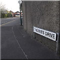
Cherries Drive is the southbound side of the Ensbury Park gyratory, and was put in in the mid 1980s when this became the A347, diverted from the main Wimborne Road through Moordown and Winton. The other three sides of the gyratory are formed from pre-existing roads. It is named, almost certainly, after the local football club, AFC Bournemouth, who are nicknamed the Cherries.
The sign is the standard Bournemouth nameplate from the 1980s, affixed with tubular steel which protrudes at each side.
This is photo no.70 of a series of 453 in my coronavirus lockdown walking project:
See https://www.geograph.org.uk/article/My-2020-Coronavirus-Lockdown-walking-project for the complete set of photos.
Image: © Chris Downer
Taken: 10 Apr 2020
0.08 miles


