IMAGES TAKEN NEAR TO
Cherries Drive, BOURNEMOUTH, BH9 2SR
Introduction
This page details the photographs taken nearby to Cherries Drive, BH9 2SR by members of the Geograph project.
The Geograph project started in 2005 with the aim of publishing, organising and preserving representative images for every square kilometre of Great Britain, Ireland and the Isle of Man.

There are currently over 7.5m images from over14,400 individuals and you can help contribute to the project by visiting https://www.geograph.org.uk
Image Map
Images are licensed for reuse under creativecommons.org/licenses/by-sa/2.0
Notes
- Clicking on the map will re-center to the selected point.
- The higher the marker number, the further away the image location is from the centre of the postcode.
Image Listing (100 Images Found)
Images are licensed for reuse under creativecommons.org/licenses/by-sa/2.0
Image
Details
Distance
1
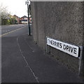
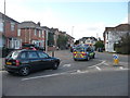
Ensbury Park: Cherries Drive
Cherries Drive is the southbound side of the Ensbury Park gyratory, and was put in in the mid 1980s when this became the A347, diverted from the main Wimborne Road through Moordown and Winton. The other three sides of the gyratory are formed from pre-existing roads. It is named, almost certainly, after the local football club, AFC Bournemouth, who are nicknamed the Cherries.
The sign is the standard Bournemouth nameplate from the 1980s, affixed with tubular steel which protrudes at each side.
This is photo no.70 of a series of 453 in my coronavirus lockdown walking project:
See https://www.geograph.org.uk/article/My-2020-Coronavirus-Lockdown-walking-project for the complete set of photos.
Image: © Chris Downer
Taken: 10 Apr 2020
0.02 miles
2
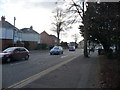
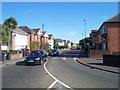
Bournemouth : Redhill Avenue
Redhill Avenue is beside Redhill Park. A motorcyclist awaits a gap in traffic to go.
Image: © Lewis Clarke
Taken: 11 Feb 2010
0.03 miles
3
Redhill: public toilets
At the southern end of the park, on the acute corner of Redhill Drive (left) and Redhill Avenue (right).
Image: © Chris Downer
Taken: 30 Jan 2008
0.03 miles
4
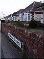
Winton: Oswald Road on St. Oswald?s Day
The highest numbered bungalows in Oswald Road, almost facing the fire station at Redhill Park. The picture was taken on St. Oswald's Day, which comes but once every four years, being on 29 February.
Image: © Chris Downer
Taken: 29 Feb 2012
0.03 miles
5
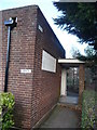
Bournemouth : Redhill Park Public Toilets
The gents section of the public toilets - the ladies is on the other side.
Image: © Lewis Clarke
Taken: 11 Feb 2010
0.03 miles
6
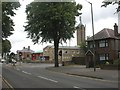
Bournemouth : Redhill Park Fire Station
Looking at the fire station from behind the front on Cherries Drive.
Image: © Lewis Clarke
Taken: 11 Feb 2010
0.03 miles
7
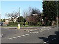
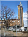
Redhill Park Fire Station
Fire station with distinctive tower at the junction of Redhill Avenue & Cherries Drive; the coat of arms above the main entrance is that of Bournemouth, so the building presumably dates to times when Bournemouth had its own fire service. Now operated by Dorset Fire & Rescue Service http://www.dorsetfire.co.uk/index.php?ref=142
Image: © Mike Faherty
Taken: 26 Jul 2009
0.04 miles
8
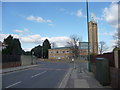
Bournemouth : Cherries Drive
The back end of the fire station on Cherries Drive.
Image: © Lewis Clarke
Taken: 11 Feb 2010
0.04 miles
9
Bournemouth : Cherries Drive Junction
A junction from Ensbury Park Road and Cherries Drive. An paramedic car is seen driving along.
Image: © Lewis Clarke
Taken: 11 Feb 2010
0.04 miles
10
Bournemouth : Ensbury Park Road
Ensbury Park Road
Image: © Lewis Clarke
Taken: 4 Oct 2007
0.04 miles