IMAGES TAKEN NEAR TO
Ensbury Park Road, BOURNEMOUTH, BH9 2SL
Introduction
This page details the photographs taken nearby to Ensbury Park Road, BH9 2SL by members of the Geograph project.
The Geograph project started in 2005 with the aim of publishing, organising and preserving representative images for every square kilometre of Great Britain, Ireland and the Isle of Man.

There are currently over 7.5m images from over14,400 individuals and you can help contribute to the project by visiting https://www.geograph.org.uk
Image Map
Images are licensed for reuse under creativecommons.org/licenses/by-sa/2.0
Notes
- Clicking on the map will re-center to the selected point.
- The higher the marker number, the further away the image location is from the centre of the postcode.
Image Listing (99 Images Found)
Images are licensed for reuse under creativecommons.org/licenses/by-sa/2.0
Image
Details
Distance
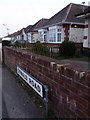
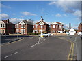
1
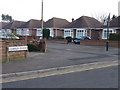
Winton: Oswald Close and Road on St. Oswald?s Day
Oswald Close comes out onto Oswald Road at the point where the latter becomes two-way, meaning that it is only possible to turn right from here. The bungalows facing us are typical of the area, although all sorts of housing is peppered around the surrounding streets.
This picture is taken on St. Oswald's Day which, being on 29 February, only occurs once in four years.
Image: © Chris Downer
Taken: 29 Feb 2012
0.06 miles
2
Bournemouth : Cherries Drive
The back end of the fire station on Cherries Drive.
Image: © Lewis Clarke
Taken: 11 Feb 2010
0.06 miles
3
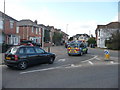
Bournemouth : Cherries Drive Junction
A junction from Ensbury Park Road and Cherries Drive. An paramedic car is seen driving along.
Image: © Lewis Clarke
Taken: 11 Feb 2010
0.06 miles
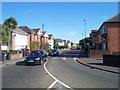
4
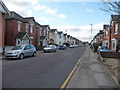
Bournemouth : Ensbury Park Road
This road leads from Boundary Road to Wimborne Road and is predominantly housing and parked cars.
Image: © Lewis Clarke
Taken: 11 Feb 2010
0.07 miles
5
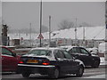
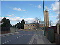
Ensbury Park: snow equals traffic jams
Overnight snow fall which continues into this morning's rush hour makes the term 'rush hour' something of an insult. If the school's hadn't already broken up for the Christmas holiday it would have been even worse!
We look out of the car while sat at a red light, as traffic crawls around the Ensbury Park gyratory system. The bungalows of Oswald Road look pretty in the background.
Image: © Chris Downer
Taken: 20 Dec 2010
0.08 miles
6
Winton: Oswald Road on St. Oswald?s Day
The highest numbered bungalows in Oswald Road, almost facing the fire station at Redhill Park. The picture was taken on St. Oswald's Day, which comes but once every four years, being on 29 February.
Image: © Chris Downer
Taken: 29 Feb 2012
0.08 miles
7

Moordown: Highfield Road
A typical Moordown side road, detached early-20th-century houses being the order of the day. Highfield Road is essentially an extension of Vicarage Road, although it has a 90º offshoot just to our right, to meet Ensbury Park Road as well.
The road sign is a standard one from around 2000-2006, perhaps a little earlier, featuring the borough coat of arms.
This is photo no.196 of a series of 453 in my coronavirus lockdown walking project:
See https://www.geograph.org.uk/article/My-2020-Coronavirus-Lockdown-walking-project for the complete set of photos.
Image: © Chris Downer
Taken: 10 Apr 2020
0.08 miles
8
Bournemouth : Ensbury Park Road
Ensbury Park Road
Image: © Lewis Clarke
Taken: 4 Oct 2007
0.08 miles
9
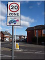
Bournemouth : Speed Sign & Road Junction
A road junction on Ensbury Park Road & Highfield Road.
Image: © Lewis Clarke
Taken: 11 Feb 2010
0.09 miles
10
Bournemouth : Highfield Road
Highfield Road with the junction to Ensbury Park Road.
Image: © Lewis Clarke
Taken: 11 Feb 2010
0.09 miles