IMAGES TAKEN NEAR TO
Morden Road, BOURNEMOUTH, BH9 2SB
Introduction
This page details the photographs taken nearby to Morden Road, BH9 2SB by members of the Geograph project.
The Geograph project started in 2005 with the aim of publishing, organising and preserving representative images for every square kilometre of Great Britain, Ireland and the Isle of Man.

There are currently over 7.5m images from over14,400 individuals and you can help contribute to the project by visiting https://www.geograph.org.uk
Image Map (Loading...)


Getting Data...Please wait
Leaflet Map data © OpenStreetMap
Images are licensed for reuse under creativecommons.org/licenses/by-sa/2.0
Notes
- Clicking on the map will re-center to the selected point.
- The higher the marker number, the further away the image location is from the centre of the postcode.
Image Listing (103 Images Found)
Images are licensed for reuse under creativecommons.org/licenses/by-sa/2.0
Image
Details
Distance
1
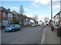
Bournemouth : Winton - Mordon Road
A road between Victoria Park Road and Vicarage Road.
Image: © Lewis Clarke
Taken: 11 Feb 2010
0.01 miles
2

Moordown: Morden Road
A short, one-segment road between Victoria Park and Vicarage Roads, we look along it from the latter end, alongside the grounds of Moordown St. John's Church of England Primary School. The fine, detached pre-war houses are the standard hereabouts.
The sign is the standard Bournemouth nameplate from the 1980s, affixed with tubular steel which protrudes at each side.
This is photo no.284 of a series of 453 in my coronavirus lockdown walking project:
See https://www.geograph.org.uk/article/My-2020-Coronavirus-Lockdown-walking-project for the complete set of photos.
Image: © Chris Downer
Taken: 19 Apr 2020
0.02 miles
3
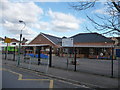
Bournemouth : Mordown St John's Primary School
Mr Peter Herbert is the headteacher of this school on Morden Road.
Image: © Lewis Clarke
Taken: 11 Feb 2010
0.02 miles
4
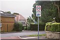
Twenty?s plenty
A schoolchild's drawing of a tortoise accompanies this sign at a 20mph speed reduction scheme near a school – Moordown St. John's CE Primary School is the building in the distance.
Image: © Chris Downer
Taken: 23 Jun 2007
0.04 miles
5
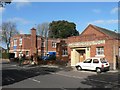
Moordown: Bournemouth Society for the Visually Impaired
This local charity was originally set up as the Bournemouth Blind Aid Society in the first decade of the 1900s. The wing to the left was living accommodation for about ten blind women. It is now a thriving charity, with some 600 members on its books and runs daily events such as cribbage sessions, bowling and chiropody, as well as a monthly newsletter on cassette and a shop selling visual aids of all sorts, from simple things like bumpy stickers for remote control buttons to television magnifying equipment to large print board games to speech software for pcs.
The right-hand wing is the Rooper Memorial Hall, which is bookable by line-dancing groups and other such organisations, and is named after one of the charity's chief committeemen of the 1940s.
Image: © Chris Downer
Taken: 1 Mar 2008
0.06 miles
6
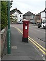
Moordown: postbox № BH9 220, Highfield Road
An Elizabeth II-reign postbox.
Image: © Chris Downer
Taken: 6 Jul 2008
0.07 miles
7
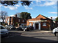
Bournemouth : Winton - Rooper Memorial Hall
The hall on Victoria Park Road is used for ballroom dancing and functions.
Image: © Lewis Clarke
Taken: 11 Feb 2010
0.07 miles
8
Bournemouth : Highfield Road
Highfield Road with the junction to Ensbury Park Road.
Image: © Lewis Clarke
Taken: 11 Feb 2010
0.07 miles
9

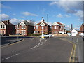
Moordown: Highfield Road
A typical Moordown side road, detached early-20th-century houses being the order of the day. Highfield Road is essentially an extension of Vicarage Road, although it has a 90º offshoot just to our right, to meet Ensbury Park Road as well.
The road sign is a standard one from around 2000-2006, perhaps a little earlier, featuring the borough coat of arms.
This is photo no.196 of a series of 453 in my coronavirus lockdown walking project:
See https://www.geograph.org.uk/article/My-2020-Coronavirus-Lockdown-walking-project for the complete set of photos.
Image: © Chris Downer
Taken: 10 Apr 2020
0.08 miles
10
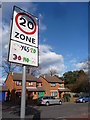
Bournemouth : Winton - Victoria Park Road & Speed Sign
A nicely decorated sign - 20 yes, and gets a happy face. 30 no, and it's all very sad.
Image: © Lewis Clarke
Taken: 11 Feb 2010
0.08 miles