IMAGES TAKEN NEAR TO
Victoria Avenue, BOURNEMOUTH, BH9 2RW
Introduction
This page details the photographs taken nearby to Victoria Avenue, BH9 2RW by members of the Geograph project.
The Geograph project started in 2005 with the aim of publishing, organising and preserving representative images for every square kilometre of Great Britain, Ireland and the Isle of Man.

There are currently over 7.5m images from over14,400 individuals and you can help contribute to the project by visiting https://www.geograph.org.uk
Image Map (Loading...)


Getting Data...Please wait
Leaflet Map data © OpenStreetMap
Images are licensed for reuse under creativecommons.org/licenses/by-sa/2.0
Notes
- Clicking on the map will re-center to the selected point.
- The higher the marker number, the further away the image location is from the centre of the postcode.
Image Listing (101 Images Found)
Images are licensed for reuse under creativecommons.org/licenses/by-sa/2.0
Image
Details
Distance
1
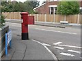
Moordown: postbox № BH9 225, Victoria Avenue
A George V-reign postbox on the corner of Victoria Avenue and Eldon Road.
Image: © Chris Downer
Taken: 6 Jul 2008
0.02 miles
2
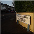
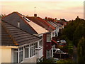
Ensbury Park: Eldon Road
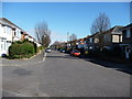
Typical of the roads in this small area loosely known as Victoria Park, Eldon Road comprises desirable, earlier 20th-century detached houses. We see it here from the Victoria Avenue crossroads.
The sign is of a design that became prevalent in Bournemouth around 1990 and was in use for most of that decade. Many are starting to look a bit shabby now, and this one has fared better than some - although the blue border is very faded in places.
The additional information tells us that numbers higher than 40 / 33 are in the other segment, behind us. The similar sign at the far end says Nos 2-40 and 5-33, the reverse direction.
This is photo no.126 of a series of 453 in my coronavirus lockdown walking project:
See https://www.geograph.org.uk/article/My-2020-Coronavirus-Lockdown-walking-project for the complete set of photos.
Image: © Chris Downer
Taken: 10 Apr 2020
0.03 miles
3
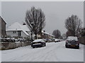
Winton: Eldon Road in snow
Looking west from the Victoria Avenue crossroads as overnight snowfall continues into the morning.
Image: © Chris Downer
Taken: 20 Dec 2010
0.03 miles
4
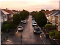
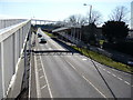
Winton: Eldon Road
Looking east along Eldon Road, typical in this immediate area with large family houses. It is cut off at this western end, with the main A347 Boundary Road passing directly below us: this view is from the footbridge.
Image: © Chris Downer
Taken: 29 Jul 2009
0.05 miles
5
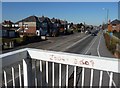
Winton: zebra crossing, Victoria Avenue
This new zebra crossing includes lit white sections of the striped posts. They are lit permanently, unlike the Belisha beacons which, of course, flash.
The crossing was installed during the summer holidays of 2007 and is no doubt of great benefit to pupils of nearby Glenmoor (girls') and Winton (boys') secondary schools, which operate close to their capacity of 900 children each.
Image: © Chris Downer
Taken: 25 Dec 2007
0.05 miles
6
Winton: Eldon Road rooftops
Looking east along the frontages of Image, in the distance, appearing to rise from the very last chimney, might just be discerned the bottom of a very weak rainbow, quite a late one at 8:45pm, although it petered out only a short distance above.
Image: © Chris Downer
Taken: 29 Jul 2009
0.06 miles
7
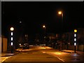
Bournemouth : Boundary Road
Boundary Road taken from the footbridge. 2004-2009 are dates, which most probably signal the years that some people went to the nearby school.
Image: © Lewis Clarke
Taken: 8 Mar 2010
0.09 miles
8
Bournemouth : Boundary Road & Footbridge
Boundary Road isn't as busy here as it can get, so sometimes it's just quicker to cross the road and not go over the bridge.
Image: © Lewis Clarke
Taken: 8 Mar 2010
0.09 miles
9
Ensbury Park: pigeon on lamppost in Boundary Road
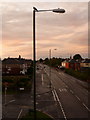
Looking north along Boundary Road – the boundary between Bournemouth and Poole (and thus, Hampshire and Dorset) until 1904 when the Kinson area to the west was transferred to Bournemouth. In 1974 the whole of Bournemouth became part of Dorset, meaning that the land to the west of here has been part of Poole (Dorset), then Bournemouth (Hants.), and finally Bournemouth (Dorset).
Image: © Chris Downer
Taken: 29 Jul 2009
0.09 miles
10
Bournemouth : Eidon Road
Eidon Road has access to Victoria Avenue and Victoria Park Road.
Image: © Lewis Clarke
Taken: 8 Mar 2010
0.10 miles