IMAGES TAKEN NEAR TO
Eldon Road, BOURNEMOUTH, BH9 2RT
Introduction
This page details the photographs taken nearby to Eldon Road, BH9 2RT by members of the Geograph project.
The Geograph project started in 2005 with the aim of publishing, organising and preserving representative images for every square kilometre of Great Britain, Ireland and the Isle of Man.

There are currently over 7.5m images from over14,400 individuals and you can help contribute to the project by visiting https://www.geograph.org.uk
Image Map (Loading...)


Getting Data...Please wait
Leaflet Map data © OpenStreetMap
Images are licensed for reuse under creativecommons.org/licenses/by-sa/2.0
Notes
- Clicking on the map will re-center to the selected point.
- The higher the marker number, the further away the image location is from the centre of the postcode.
Image Listing (106 Images Found)
Images are licensed for reuse under creativecommons.org/licenses/by-sa/2.0
Image
Details
Distance
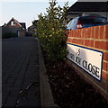
1
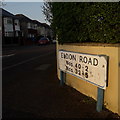
Ensbury Park: Eldon Road
Typical of the roads in this small area loosely known as Victoria Park, Eldon Road comprises desirable, earlier 20th-century detached houses. We see it here from the Victoria Avenue crossroads.
The sign is of a design that became prevalent in Bournemouth around 1990 and was in use for most of that decade. Many are starting to look a bit shabby now, and this one has fared better than some - although the blue border is very faded in places.
The additional information tells us that numbers higher than 40 / 33 are in the other segment, behind us. The similar sign at the far end says Nos 2-40 and 5-33, the reverse direction.
This is photo no.126 of a series of 453 in my coronavirus lockdown walking project:
See https://www.geograph.org.uk/article/My-2020-Coronavirus-Lockdown-walking-project for the complete set of photos.
Image: © Chris Downer
Taken: 10 Apr 2020
0.05 miles
2
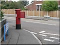
Moordown: postbox № BH9 225, Victoria Avenue
A George V-reign postbox on the corner of Victoria Avenue and Eldon Road.
Image: © Chris Downer
Taken: 6 Jul 2008
0.05 miles
3
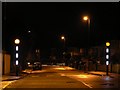
Winton: zebra crossing, Victoria Avenue
This new zebra crossing includes lit white sections of the striped posts. They are lit permanently, unlike the Belisha beacons which, of course, flash.
The crossing was installed during the summer holidays of 2007 and is no doubt of great benefit to pupils of nearby Glenmoor (girls') and Winton (boys') secondary schools, which operate close to their capacity of 900 children each.
Image: © Chris Downer
Taken: 25 Dec 2007
0.06 miles
4

Winton: Namu Road
This curiously named road is generally pronounced "Name-you", but I have heard "Nar-mew" as well. I am not sure of the derivation but I presume it may be someone's surname? Anyway, it comprises fine inter-War detached houses which are typical of this immediate area. Unlike some of the older houses, there is at least room for off-road parking for most of them.
The sign is the standard Bournemouth nameplate from the 1980s, more often seen affixed with tubular steel which protrudes at each side, but this one is high on a lamppost facing Jameson Road.
This is photo no.288 of a series of 453 in my coronavirus lockdown walking project:
See https://www.geograph.org.uk/article/My-2020-Coronavirus-Lockdown-walking-project for the complete set of photos.
Image: © Chris Downer
Taken: 19 Apr 2020
0.07 miles
5
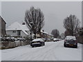
Winton: Eldon Road in snow
Looking west from the Victoria Avenue crossroads as overnight snowfall continues into the morning.
Image: © Chris Downer
Taken: 20 Dec 2010
0.08 miles
6
Moordown: Henry Joy Close
A recent (in the last couple of years) small development of five properties around the back of houses in Victoria Park Road.
The road is named after builder Henry Joy, who was responsible for several notable buildings in Bournemouth, including the Arcade in the town centre and Westbourne Arcade.
The sign looks like a standard council one, but I am not sure if it is because it is not of a 100% standard design, and the specification of the house numbers is not usual.
This is photo no.154 of a series of 453 in my coronavirus lockdown walking project:
See https://www.geograph.org.uk/article/My-2020-Coronavirus-Lockdown-walking-project for the complete set of photos.
Image: © Chris Downer
Taken: 10 Apr 2020
0.09 miles
7
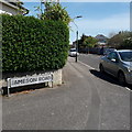
Winton: Jameson Road
Right at the limit of my 2km radius from home, it is just the part of it visible here that is within the circle. We view it from Namu Road, although most will be familiar with the other end of it, on the main Wimborne Road.
The sign is the standard Bournemouth nameplate from the 1980s, affixed with tubular steel which protrudes at each side.
This is photo no.196 of a series of 453 in my coronavirus lockdown walking project:
See https://www.geograph.org.uk/article/My-2020-Coronavirus-Lockdown-walking-project for the complete set of photos.
Image: © Chris Downer
Taken: 19 Apr 2020
0.10 miles
8
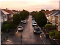
Winton: Eldon Road
Looking east along Eldon Road, typical in this immediate area with large family houses. It is cut off at this western end, with the main A347 Boundary Road passing directly below us: this view is from the footbridge.
Image: © Chris Downer
Taken: 29 Jul 2009
0.10 miles
9
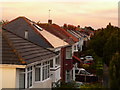
Winton: Eldon Road rooftops
Looking east along the frontages of Image, in the distance, appearing to rise from the very last chimney, might just be discerned the bottom of a very weak rainbow, quite a late one at 8:45pm, although it petered out only a short distance above.
Image: © Chris Downer
Taken: 29 Jul 2009
0.12 miles
10

Moordown: Highfield Road
A typical Moordown side road, detached early-20th-century houses being the order of the day. Highfield Road is essentially an extension of Vicarage Road, although it has a 90º offshoot just to our right, to meet Ensbury Park Road as well.
The road sign is a standard one from around 2000-2006, perhaps a little earlier, featuring the borough coat of arms.
This is photo no.196 of a series of 453 in my coronavirus lockdown walking project:
See https://www.geograph.org.uk/article/My-2020-Coronavirus-Lockdown-walking-project for the complete set of photos.
Image: © Chris Downer
Taken: 10 Apr 2020
0.13 miles