IMAGES TAKEN NEAR TO
Namu Road, BOURNEMOUTH, BH9 2QY
Introduction
This page details the photographs taken nearby to Namu Road, BH9 2QY by members of the Geograph project.
The Geograph project started in 2005 with the aim of publishing, organising and preserving representative images for every square kilometre of Great Britain, Ireland and the Isle of Man.

There are currently over 7.5m images from over14,400 individuals and you can help contribute to the project by visiting https://www.geograph.org.uk
Image Map (Loading...)


Getting Data...Please wait
Leaflet Map data © OpenStreetMap
Images are licensed for reuse under creativecommons.org/licenses/by-sa/2.0
Notes
- Clicking on the map will re-center to the selected point.
- The higher the marker number, the further away the image location is from the centre of the postcode.
Image Listing (102 Images Found)
Images are licensed for reuse under creativecommons.org/licenses/by-sa/2.0
Image
Details
Distance
1
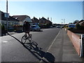
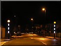
Bournemouth : Winton - Namu Road
A cyclist takes advantage of a lovely day to go for a bike ride.
Image: © Lewis Clarke
Taken: 8 Mar 2010
0.02 miles
2
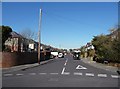
Bournemouth : Winton - Namu Road
Namu Road on the junction with Mansfield Road, even though according to the map, if you turn right from this photo, you're still in Namu Road.
Image: © Lewis Clarke
Taken: 8 Mar 2010
0.03 miles
3
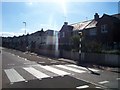
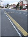
Bournemouth : Zebra Crossing on Victoria Avenue
A crossing on Victoria Avenue to help pedestrians safely cross.
Image: © Lewis Clarke
Taken: 4 Oct 2007
0.03 miles
4
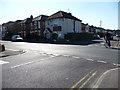
Bournemouth : Winton - Namu Road & Bengal Road Junction
A road junction which takes you from Namu Road, and left of the road is Bengal Avenue, right is Victoria Avenue.
Image: © Lewis Clarke
Taken: 8 Mar 2010
0.03 miles
5
STOP, but no BUS
It appears that the painters have omitted a word; in any case, buses no longer come along Bengal Road so it no longer matters.
Image: © Chris Downer
Taken: 14 Apr 2008
0.04 miles
6
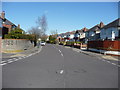
Bournemouth : Winton - Norton Road
Norton Road in Bournemouth which leads from Boundary Road to Victoria Park Road.
Image: © Lewis Clarke
Taken: 8 Mar 2010
0.06 miles
7
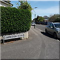
Winton: Jameson Road
Right at the limit of my 2km radius from home, it is just the part of it visible here that is within the circle. We view it from Namu Road, although most will be familiar with the other end of it, on the main Wimborne Road.
The sign is the standard Bournemouth nameplate from the 1980s, affixed with tubular steel which protrudes at each side.
This is photo no.196 of a series of 453 in my coronavirus lockdown walking project:
See https://www.geograph.org.uk/article/My-2020-Coronavirus-Lockdown-walking-project for the complete set of photos.
Image: © Chris Downer
Taken: 19 Apr 2020
0.10 miles
8
Bournemouth : Winton - Greenwood Road
This photo was taken from Namu Road and shows a residential area.
Image: © Lewis Clarke
Taken: 8 Mar 2010
0.11 miles
9
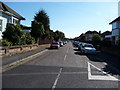
Winton: zebra crossing, Victoria Avenue
This new zebra crossing includes lit white sections of the striped posts. They are lit permanently, unlike the Belisha beacons which, of course, flash.
The crossing was installed during the summer holidays of 2007 and is no doubt of great benefit to pupils of nearby Glenmoor (girls') and Winton (boys') secondary schools, which operate close to their capacity of 900 children each.
Image: © Chris Downer
Taken: 25 Dec 2007
0.11 miles
10
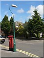
Winton: postbox № BH9 211, Edgehill Road
A Victorian postbox in Edgehill Road; both the box and the lamppost alongside are very well painted.
Image: © Chris Downer
Taken: 6 Jul 2008
0.13 miles