IMAGES TAKEN NEAR TO
Jameson Road, BOURNEMOUTH, BH9 2QG
Introduction
This page details the photographs taken nearby to Jameson Road, BH9 2QG by members of the Geograph project.
The Geograph project started in 2005 with the aim of publishing, organising and preserving representative images for every square kilometre of Great Britain, Ireland and the Isle of Man.

There are currently over 7.5m images from over14,400 individuals and you can help contribute to the project by visiting https://www.geograph.org.uk
Image Map (Loading...)


Getting Data...Please wait
Leaflet Map data © OpenStreetMap
Images are licensed for reuse under creativecommons.org/licenses/by-sa/2.0
Notes
- Clicking on the map will re-center to the selected point.
- The higher the marker number, the further away the image location is from the centre of the postcode.
Image Listing (126 Images Found)
Images are licensed for reuse under creativecommons.org/licenses/by-sa/2.0
Image
Details
Distance
1
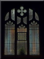
Winton: a window of Victoria Park Methodist Church
Looking into Image during the first minute of Christmas Day, with the Midnight Mass service in progress. A small Christmas tree graces the window sill.
Image: © Chris Downer
Taken: 25 Dec 2009
0.03 miles
2
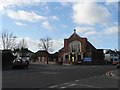
Winton: Victoria Park Methodist Church
This church stands on the corner of Edgehill (left) and Jameson Roads.
Image: © Chris Downer
Taken: 1 Mar 2008
0.03 miles
3
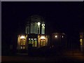
Winton: evening service in progress
While a Sunday evening service is underway at Image, the internal and external lights give us a striking view of the church frontage.
Image: © Chris Downer
Taken: 1 Feb 2009
0.03 miles
4
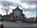
Bournemouth : Winton - Victoria Park Methodist Church
The Church is on the next road back from the main Wimborne Road running from Winton shopping centre through to Moordown.
Image: © Lewis Clarke
Taken: 11 Feb 2010
0.03 miles
5
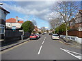
Bournemouth : Winton - Edgehill Road
On the road junction with Jameson Road looking forward at Edgehill Road.
Image: © Lewis Clarke
Taken: 11 Feb 2010
0.04 miles
6
Bournemouth : Winton - Victoria Park Methodist Church
A view of the church taken from Edgehill Road in Winton.
Image: © Lewis Clarke
Taken: 11 Feb 2010
0.05 miles
7
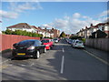
Bournemouth : Winton - Library Road
Houses on the road in Winton looking towards Winborne Road.
Image: © Lewis Clarke
Taken: 11 Feb 2010
0.06 miles
8

Bournemouth : Winton - Edgehill Road
A postman is out doing the rounds late into the afternoon.
Image: © Lewis Clarke
Taken: 17 Mar 2011
0.08 miles
9
Winton: Lampton Gardens
An infill development dating from around 2000 (slight guesswork here), taking in the rear workshop/yard area of the former Caffyns Fiat dealership on the main Wimborne Road.
The road sign is a standard one from around 2000-2006 featuring the borough coat of arms and, in this case, incorporating a no-through road sign.
This is photo no.235 of a series of 453 in my coronavirus lockdown walking project:
See https://www.geograph.org.uk/article/My-2020-Coronavirus-Lockdown-walking-project for the complete set of photos.
Image: © Chris Downer
Taken: 13 May 2020
0.09 miles
10
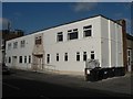
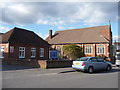
Winton: YMCA
It is highly unusual for the YMCA to have a branch in such a non-town centre location. Winton YMCA was built in 1927, replacing a more primitive building nearby, according to a former billiards player whom I talked to, who was a member of the Winton YMCA billiards team that won the local league title in the season 1926-27.
Image: © Chris Downer
Taken: 1 Mar 2008
0.09 miles