IMAGES TAKEN NEAR TO
Jameson Road, BOURNEMOUTH, BH9 2QD
Introduction
This page details the photographs taken nearby to Jameson Road, BH9 2QD by members of the Geograph project.
The Geograph project started in 2005 with the aim of publishing, organising and preserving representative images for every square kilometre of Great Britain, Ireland and the Isle of Man.

There are currently over 7.5m images from over14,400 individuals and you can help contribute to the project by visiting https://www.geograph.org.uk
Image Map (Loading...)


Getting Data...Please wait
Leaflet Map data © OpenStreetMap
Images are licensed for reuse under creativecommons.org/licenses/by-sa/2.0
Notes
- Clicking on the map will re-center to the selected point.
- The higher the marker number, the further away the image location is from the centre of the postcode.
Image Listing (133 Images Found)
Images are licensed for reuse under creativecommons.org/licenses/by-sa/2.0
Image
Details
Distance
1
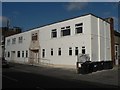
Winton: YMCA
It is highly unusual for the YMCA to have a branch in such a non-town centre location. Winton YMCA was built in 1927, replacing a more primitive building nearby, according to a former billiards player whom I talked to, who was a member of the Winton YMCA billiards team that won the local league title in the season 1926-27.
Image: © Chris Downer
Taken: 1 Mar 2008
0.02 miles
2
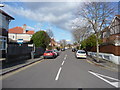
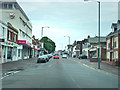
Bournemouth : Winton - Edgehill Road
On the road junction with Jameson Road looking forward at Edgehill Road.
Image: © Lewis Clarke
Taken: 11 Feb 2010
0.03 miles
3
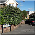
Winton: Lampton Gardens
An infill development dating from around 2000 (slight guesswork here), taking in the rear workshop/yard area of the former Caffyns Fiat dealership on the main Wimborne Road.
The road sign is a standard one from around 2000-2006 featuring the borough coat of arms and, in this case, incorporating a no-through road sign.
This is photo no.235 of a series of 453 in my coronavirus lockdown walking project:
See https://www.geograph.org.uk/article/My-2020-Coronavirus-Lockdown-walking-project for the complete set of photos.
Image: © Chris Downer
Taken: 13 May 2020
0.05 miles
4
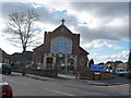
Bournemouth : Winton - Victoria Park Methodist Church
The Church is on the next road back from the main Wimborne Road running from Winton shopping centre through to Moordown.
Image: © Lewis Clarke
Taken: 11 Feb 2010
0.05 miles
5
Winton: footpath L01 emerges onto Wimborne Road
This short public footpath comes from Midland Road and arrives here on the main Wimborne Road, alongside the old Job Centre building (on our left).
See Image for the view towards us from the roadside ahead, and Image for the next view on the path behind us.
Image: © Chris Downer
Taken: 26 Feb 2017
0.05 miles
6
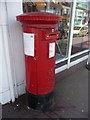
Bournemouth : Winton, Wimborne Road Postbox
A post box on Wimborne Road which has been the victim of vandalism - there is a sign saying it's been closed up due to people putting fireworks in post.
Image: © Lewis Clarke
Taken: 20 Mar 2009
0.06 miles
7
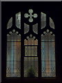
Winton: a window of Victoria Park Methodist Church
Looking into Image during the first minute of Christmas Day, with the Midnight Mass service in progress. A small Christmas tree graces the window sill.
Image: © Chris Downer
Taken: 25 Dec 2009
0.06 miles
8
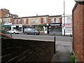
Wimborne Road Winton
Jameson Road just visible on left
Image: © Chris Gunns
Taken: 25 May 2009
0.06 miles
9
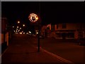
Winton: Santa has come early
The council workmen have been putting up the Christmas lights in the last week, in readiness for the festive season; they are due to be switched on probably during the last weekend in November. However, just this one seems to have an electrical fault resulting in this eager Santa making a premature appearance. If they were all lit up, the scene would be more like this: Image
Image: © Chris Downer
Taken: 3 Nov 2009
0.06 miles
10
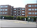
Bournemouth : Winton, Talbot Court
Talbot Court is a residential building on Wimborne Road. There is a bus stop just outside as we can see here.
Image: © Lewis Clarke
Taken: 20 Mar 2009
0.06 miles