
IMAGES TAKEN NEAR TO
Calvin Road, BOURNEMOUTH, BH9 1LN
Introduction
This page details the photographs taken nearby to Calvin Road, BH9 1LN by members of the Geograph project.
The Geograph project started in 2005 with the aim of publishing, organising and preserving representative images for every square kilometre of Great Britain, Ireland and the Isle of Man.

There are currently over 7.5m images from over14,400 individuals and you can help contribute to the project by visiting https://www.geograph.org.uk
Image Map
Images are licensed for reuse under creativecommons.org/licenses/by-sa/2.0
Notes
- Clicking on the map will re-center to the selected point.
- The higher the marker number, the further away the image location is from the centre of the postcode.
Image Listing (159 Images Found)
Images are licensed for reuse under creativecommons.org/licenses/by-sa/2.0
Image
Details
Distance
1
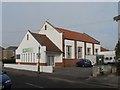
Winton: Bournemouth Community Church Centre
Situated in Calvin Road, according to the 1975 Kelly's Directory this was then the Winton Free Evangelical Church. It is now Bournemouth Community Church Centre, and in fairly recent years the porch section has been added, rather pleasingly mirroring the original façade.
Image: © Chris Downer
Taken: 24 Feb 2008
0.02 miles
2
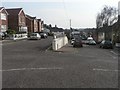
Winton: split level section of Calvin Road
The hilly terrain around here is overcome in Calvin Road with a dead-end section and the through section, separated by an ever-heightening wall.
Image: © Chris Downer
Taken: 24 Feb 2008
0.05 miles
3
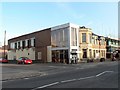
Winton: Liberal Club
Winton Liberal Club is at 521 Wimborne Road, on the corner of Calvin Road. The building site next door used to be the BP filling station, which closed in November 2006 and lay dormant for over a year before reconstruction began.
Image: © Chris Downer
Taken: 23 Mar 2008
0.06 miles
4
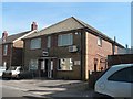
Winton: from maps to gaps
This building, at 2 Pine Road, used to be a local office of the Ordnance Survey; it is now a dental surgery.
Image: © Chris Downer
Taken: 11 May 2008
0.06 miles
5
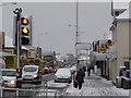
Winton: traffic buildup on snowy day
Snow that was unforessen first thing this morning has caused congestion in Wimborne Road, as buses and other large vehicles make their way gingerly down Image, causing tailbacks behind them.
This burst of snowfall was surprising, since it had started rainy this morning. By now the snowfall had been going on for a couple of hours. By nightfall, the main carriageways of all the roads were clear of snow and ice, making this the severest snowfall I think I have ever seen that had started and almost disappeared all on the same day.
Throughout the day, the BBC weather forecast suggested temperatures of about 2ºC and 'light rain'.
Image: © Chris Downer
Taken: 6 Feb 2009
0.07 miles
6
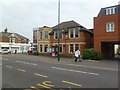
Winton Liberal Club
On Wimborne Road, at the corner of Calvin Road; with a foundation stone dated 1913.
Image: © Mike Faherty
Taken: 6 Jan 2012
0.07 miles
7
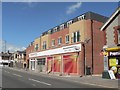
Winton: new Sainsbury?s Local
This was the BP filling station until November 2006. While the former manager took over the premises to the right, as a grocery store and newsagent, the site lay idle for a year before the new Sainsbury’s was built. It will open on 9 July 2008. I wonder if the grocery store will survive with its new neighbour.
Image: © Chris Downer
Taken: 22 Jun 2008
0.07 miles
8
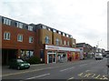
Winton, Sainsbury's Local
Opened in September 2008, on Wimborne Road.
Image: © Mike Faherty
Taken: 6 Jan 2012
0.08 miles
9
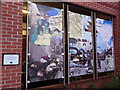
Winton: mural at Sainsbury?s
This mural was designed by students on a vocational arts course at nearby Winton Arts & Media College (formerly Winton Boys' School - see Image and is displayed by the car-park entrance of Sainsbury's (see Image; it is just to the left of the main door and is visible in Image).
Among the recognisable buildings featured are Winton Library (in the left-hand panel; see Image) and the corner piece of the Plaza, predecessor to the former Continental cinema (in the middle panel; the Continental is now occupied by Image).
Image: © Chris Downer
Taken: 16 Mar 2013
0.08 miles
10
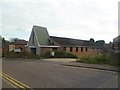
Winton URC
On Luther Road. http://www.wintonurc.org.uk/
Image: © Mike Faherty
Taken: 6 Jan 2012
0.08 miles