IMAGES TAKEN NEAR TO
Markham Road, BOURNEMOUTH, BH9 1HY
Introduction
This page details the photographs taken nearby to Markham Road, BH9 1HY by members of the Geograph project.
The Geograph project started in 2005 with the aim of publishing, organising and preserving representative images for every square kilometre of Great Britain, Ireland and the Isle of Man.

There are currently over 7.5m images from over14,400 individuals and you can help contribute to the project by visiting https://www.geograph.org.uk
Image Map (Loading...)


Getting Data...Please wait
Leaflet Map data © OpenStreetMap
Images are licensed for reuse under creativecommons.org/licenses/by-sa/2.0
Notes
- Clicking on the map will re-center to the selected point.
- The higher the marker number, the further away the image location is from the centre of the postcode.
Image Listing (51 Images Found)
Images are licensed for reuse under creativecommons.org/licenses/by-sa/2.0
Image
Details
Distance
1
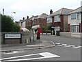
Winton: postbox № BH9 121, Markham Road
An Edward VII-reign box in Markham Road, close to the crossroads with Somerley Road – two roads pretty typical of this part of Bournemouth.
Image: © Chris Downer
Taken: 4 Jul 2008
0.03 miles
2
Bournemouth : Winton, Wycliffe Road
Wycliffe Road has its very own Violin Shop.
Image: © Lewis Clarke
Taken: 20 Mar 2009
0.11 miles
3
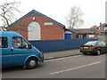
Winton: Boys? Brigade
Situated on the corner of Wycliffe and Bingham Roads, opposite Bemister Road.
Image: © Chris Downer
Taken: 24 Feb 2008
0.12 miles
4
Bournemouth : Winton, Bingham Road
Yellow Taxis wait for the school day to finish to take people home - although it's a lovely day for walking.
Image: © Lewis Clarke
Taken: 20 Mar 2009
0.13 miles
5
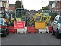
No parking beyond this point...
A close up of the signs accompanying these roadworks (see Image). I would like to see someone try to park beyond that point!
Image: © Chris Downer
Taken: 14 Apr 2008
0.13 miles
6
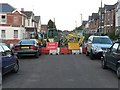
Winton: Green Road undergoes work
Major maintenance work in Green Road has closed the road from April to June 2008. This part, through housing built before the need for off-road parking was foreseen, is a tricky part for bus drivers on the route 24, which does a left turn followed shortly by a right (following the yellow road on the map), and queues often occur, short in terms of length but long in terms of time. The current diversion is no easier.
Image: © Chris Downer
Taken: 14 Apr 2008
0.13 miles
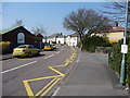
7
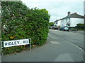
Bournemouth : Winton - Ridley Road Sign
Image: © Lewis Clarke
Taken: 26 Apr 2009
0.13 miles
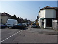
8
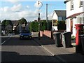
Winton: postbox № BH9 89, Ridley Road
Looking along Ridley Road past this Victorian postbox. According to large scale maps published in the 1960s, the postbox used to be just around the corner in Luther Road, to the left as we look here. As implied in this picture, Wednesday is bin day in Ridley Road.
Image: © Chris Downer
Taken: 2 Jul 2008
0.13 miles
9
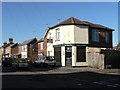
Winton: The Violin Shop
Not your usual corner shop!
Image: © Chris Downer
Taken: 30 Jan 2008
0.15 miles
10
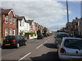
Charminster, Hankinson Road
Mixed Edwardian houses in a road named after Bournemouth's first mayor, Thomas James Hankinson, previously chairman of the Bournemouth Commissioners, later mayor of Bournemouth Borough Council from 1890. http://www.bournemouth.gov.uk/Residents/Historical_Bournemouth/council_history.asp
Image: © Mike Faherty
Taken: 28 Mar 2009
0.16 miles