IMAGES TAKEN NEAR TO
Charminster Road, BOURNEMOUTH, BH8 9SA
Introduction
This page details the photographs taken nearby to Charminster Road, BH8 9SA by members of the Geograph project.
The Geograph project started in 2005 with the aim of publishing, organising and preserving representative images for every square kilometre of Great Britain, Ireland and the Isle of Man.

There are currently over 7.5m images from over14,400 individuals and you can help contribute to the project by visiting https://www.geograph.org.uk
Image Map (Loading...)


Getting Data...Please wait
Leaflet Map data © OpenStreetMap
Images are licensed for reuse under creativecommons.org/licenses/by-sa/2.0
Notes
- Clicking on the map will re-center to the selected point.
- The higher the marker number, the further away the image location is from the centre of the postcode.
Image Listing (47 Images Found)
Images are licensed for reuse under creativecommons.org/licenses/by-sa/2.0
Image
Details
Distance
1
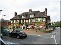
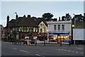
The Fiveways public house Charminster
Five roads meet here.
Image: © Clive Perrin
Taken: 13 Sep 2006
0.03 miles
2
Charminster Road Bournemouth Dorset
A very smart paint and wallpaper store here.
Image: © Clive Perrin
Taken: 13 Sep 2006
0.05 miles
3
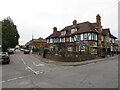
The Fiveways pub, Charminster, Bournemouth
The Fiveways pub in Charminster, a suburb of Bournemouth.
Image: © Malc McDonald
Taken: 7 Feb 2022
0.06 miles
4
Charminster: Fampoux Gardens memorial
The memorial stone in Image, explaining its name. The simple plate says, "These gardens, laid out by ex servicemen, are named to commemorate the gallant stand of the Hampshires at Fampoux." Another side of the stone has a rectangular space for a further plate which presumably told more.
Image: © Chris Downer
Taken: 22 Jun 2008
0.06 miles
5
Charminster: Fampoux Gardens
These small gardens abut the eastern end of Green Road and adjoin Firbank Road. At the top end is a small memorial stone (Image) which says simply, "These gardens, laid out by ex servicemen, are named to commemorate the gallant stand of the Hampshires at Fampoux." The workmen's cabins visible at the far end are here during the council's resurfacing of Firbank and Green Roads.
For much more discussion on this small garden, see the Winton Forum page here: http://www.wintonforum.co.uk/fampoux.html
Image: © Chris Downer
Taken: 22 Jun 2008
0.06 miles
6
Charminster: nameless fish & chip shop
This corner premises was a Spar grocery store until the late 1990s, and was taken over by this fish & chip shop after a couple of years of emptiness. It appears bereft of an actual name, but it is open, as you can see, on a Sunday evening.
The Fiveways pub is next door.
Image: © Chris Downer
Taken: 2 Mar 2008
0.08 miles
7

Charminster: Queen?s Park Terrace (detail)
Detail of the lettering in the central façade of Image
Image: © Chris Downer
Taken: 14 Apr 2008
0.08 miles
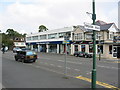
8
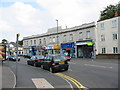
Queens Park Terrace Charminster Bournemouth Dorset
Small shops in building that looks a bit 1930's
Image: © Clive Perrin
Taken: 13 Sep 2006
0.09 miles
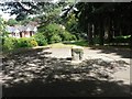
9
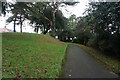
Turf Zone "FampouxGarden"
Small Park off Green Road.
Image: © Ian S
Taken: 15 Nov 2022
0.09 miles
10
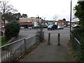
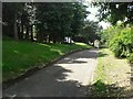
Charminster: footpath K01 arrives at the Fiveways
The public footpath from Ashling Crescent comes down onto Charminster Road opposite Charminster Avenue, at what is known as the Fiveways thanks to another junction just to the left, and the Fiveways pub which stands between them (the pub wall is just in shot at the extreme left).
The shop on the corner has been several things over the years and after some time closed is now a general store (see Image from 2008, which also has the Fiveways pub in view).
See Image for the view towards us from across the road, and Image for the view up the path behind us, with links to further photos on the path.
Image: © Chris Downer
Taken: 25 Feb 2017
0.09 miles