IMAGES TAKEN NEAR TO
Charminster Road, BOURNEMOUTH, BH8 9QJ
Introduction
This page details the photographs taken nearby to Charminster Road, BH8 9QJ by members of the Geograph project.
The Geograph project started in 2005 with the aim of publishing, organising and preserving representative images for every square kilometre of Great Britain, Ireland and the Isle of Man.

There are currently over 7.5m images from over14,400 individuals and you can help contribute to the project by visiting https://www.geograph.org.uk
Image Map
Images are licensed for reuse under creativecommons.org/licenses/by-sa/2.0
Notes
- Clicking on the map will re-center to the selected point.
- The higher the marker number, the further away the image location is from the centre of the postcode.
Image Listing (83 Images Found)
Images are licensed for reuse under creativecommons.org/licenses/by-sa/2.0
Image
Details
Distance
1
Charminster: Lower Charminster Road Post Office
Lower Charminster Road Post Office was established in 1910; it became a Money Order and Savings Bank on 1 September 1922 and a Telegraph Office on 3 March 1926. In the mid-1990s it moved from 343-345 Charminster Road to new premises within the One Stop convenience store a short distance away at no. 269-273, which became the Co-Op as you see now. (The postbox was not moved, however: see Image) This was more suitable premises in that the old shop had two steps up to its entrance whereas this shop has level access and automatic doors. It was announced this week that it is to be a casualty of the 2008 closures, whereby 2,500 offices will close, meaning that it will close permanently in October 2008, a year or two short of its centenary.
UPDATE: The office finally closed at 1pm on Wednesday 29 October. I visited the Co-Op just after 5 o'clock that evening, by which time there was already no visible sign that a post office had ever been contained within the store. Only the oval sign outside alluded to that fact.
The name 'Lower' Charminster Road distinguishes this office from the one called plain Charminster Road, farther south at no. 63-65.
The Co-Op is open 24 hours a day; the spherical foliage in the foreground is one of several adorning both frontages of the restaurant opposite.
Image: © Chris Downer
Taken: 24 Sep 2008
0.03 miles
2
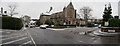
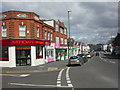
Charminster Road, Bournemouth
Charminster Road in the suburbs of Bournemouth. This road is the B3063.
Image: © Malc McDonald
Taken: 7 Feb 2022
0.06 miles
3
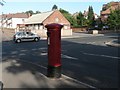
Charminster: postbox № BH9 143, Fitzharris Avenue
An Edward VII-reign postbox on the corner of Fitzharris Avenue (behind camera) and Charminster Road. In the background is Image
Charminster Road is the boundary of BH8 and BH9 – if the postbox had been just around the corner it would have a BH8 number.
Image: © Chris Downer
Taken: 25 Jun 2008
0.06 miles
4

Winton Rec, entrance
Large multi-purpose recreation ground. Here, the fir-lined entrance from Linwood Road http://www.bournemouth.gov.uk/Library/PDF/Landscape/DRAFT%20WOODLAND%20STRATEGY%2006-2006.pdf
Image: © Mike Faherty
Taken: 28 Mar 2009
0.07 miles
5
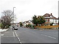
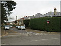
Richmond Park Avenue, Bournemouth
Richmond Park Avenue is a residential road in the suburbs of Bournemouth.
Image: © Malc McDonald
Taken: 7 Feb 2022
0.07 miles
6
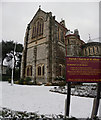
Bournemouth : Parish Church of St Alban
Parish Church of St Alban
Image: © Lewis Clarke
Taken: 6 Feb 2009
0.08 miles
7
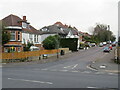
Linwood Road, Winton, Bournemouth
Linwood Road is a residential road in Winton, a suburb of Bournemouth. The road is a one-way street.
Image: © Malc McDonald
Taken: 7 Feb 2022
0.08 miles
8
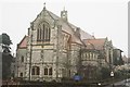
Bournemouth : Parish Church of St Alban
A church taken on Fitzharris Avenue.
Image: © Lewis Clarke
Taken: 6 Feb 2009
0.08 miles
10
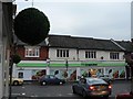
Charminster, Charminster Road
Mixed Edwardian/1920s shopping parade on the Western side of Charminster Road; mostly independent shops, with only one empty. Estate agent, gallery, flooring, Indian take-away, Thai restaurant, hair salon, motorbikes, decor.
Image: © Mike Faherty
Taken: 28 Mar 2009
0.09 miles