IMAGES TAKEN NEAR TO
Normanhurst Avenue, BOURNEMOUTH, BH8 9NR
Introduction
This page details the photographs taken nearby to Normanhurst Avenue, BH8 9NR by members of the Geograph project.
The Geograph project started in 2005 with the aim of publishing, organising and preserving representative images for every square kilometre of Great Britain, Ireland and the Isle of Man.

There are currently over 7.5m images from over14,400 individuals and you can help contribute to the project by visiting https://www.geograph.org.uk
Image Map
Images are licensed for reuse under creativecommons.org/licenses/by-sa/2.0
Notes
- Clicking on the map will re-center to the selected point.
- The higher the marker number, the further away the image location is from the centre of the postcode.
Image Listing (54 Images Found)
Images are licensed for reuse under creativecommons.org/licenses/by-sa/2.0
Image
Details
Distance
1
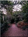
Strouden: footpath K18 heads for Wordsworth Avenue
This public right of way, footpath K18, leads through the woods from Wordsworth Avenue to Broad Avenue. We see it here heading downhill in the opposite direction.
See Image for the next view on the path ahead, and Image for the next view behind us - each with links to further photos on the route.
Image: © Chris Downer
Taken: 5 Oct 2016
0.03 miles
2
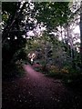
Strouden: footpath K18 heads uphill
This public right of way, footpath K18, leads through the woods from Wordsworth Avenue to Broad Avenue. We see it here heading uphill about midway along its journey.
See Image for the next view on the path ahead, and Image for the next view behind us - each with links to further photos on the route.
Image: © Chris Downer
Taken: 5 Oct 2016
0.03 miles
3
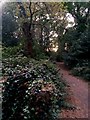
Strouden: ivy-clad tree stump on footpath K18
Looking over the remains of a long-gone tree along this public footpath, which leads through the woods from Wordsworth Avenue to Broad Avenue.
See Image for the next view on the path ahead, and Image for the next view behind us - each with links to further photos on the route.
Image: © Chris Downer
Taken: 5 Oct 2016
0.04 miles
4
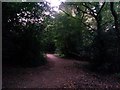
Strouden: footpath K18 heads for Broad Avenue
This public right of way, footpath K18, leads through the woods from Wordsworth Avenue to Broad Avenue. We see it here shortly after the start, heading properly into the woods from Wordsworth Avenue.
See Image for the next view on the path ahead, and Image for the next view behind us - each with links to further photos on the route.
Image: © Chris Downer
Taken: 5 Oct 2016
0.05 miles
5
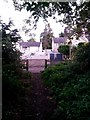
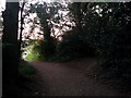
Strouden: footpath K30 arrives on Normanhurst Avenue
This short public footpath heads into the woods behind us from Normanhurst Avenue and joins another footpath, number K18, once under cover of the trees.
See Image for the view towards us from across the road, and Image for the next view behind us, with links to further photos on the route.
Image: © Chris Downer
Taken: 5 Oct 2016
0.05 miles
6
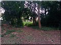
Strouden: northern end of footpath K30
We are stood just inside the woods at the dead end of Wordsworth Avenue, on the divergence of two public footpaths - path K18 heading right to Broad Avenue, and this shorter path, K30, to Normanhurst Avenue.
See:
Image for the next view on path K30 ahead;
Image for the next view on path K18, right
(each with links to further photos along the routes); and
Image for the view left onto Wordsworth Avenue.
Image: © Chris Downer
Taken: 5 Oct 2016
0.05 miles
7
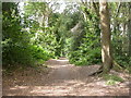
Strouden, Wordsworth Woods
Predominantly oak woodland, around two sides of Image; recently renovated, with older trees removed and paths created. For more information, see page 55 at http://www.bournemouth.gov.uk/Library/PDF/Landscape/DRAFT%20WOODLAND%20STRATEGY%2006-2006.pdf
Image: © Mike Faherty
Taken: 21 Jun 2009
0.05 miles
8
Strouden: footpath K18 joins the path from Bradpole Road
This public right of way, footpath K18, leads through the woods from Wordsworth Avenue and here joins a more obviously followable route (right) down to Bradpole Road. The course of footpath K18 continues left to Broad Avenue.
See Image for the next photo on the path ahead, and Image for the next view behind us - each with links to further photos on the route.
Image: © Chris Downer
Taken: 5 Oct 2016
0.05 miles
9
Strouden: footpath K18 diverges from the obvious path
The main path here leads from the end of Broad Avenue, behind us, to Bradpole Road by opening out from the woods just ahead and becoming a paved path through a public open space.
The public right of way, footpath K18, though, bears right to continue through the woods to Wordsworth Avenue.
See Image for the next view on the path behind us, and Image for the next view on the path to the right - each with links to further photos on the route.
Image: © Chris Downer
Taken: 5 Oct 2016
0.05 miles
10
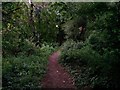
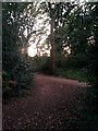
Strouden: into the woods on footpath K30
This short public footpath heads into the woods from Normanhurst Avenue and joins another public footpath, K18, shortly ahead near the dead end of Wordsworth Avenue.
See Image for the view behind us onto Normanhurst Avenue, and Image for the next view on the path ahead, with links to further photos on this path and the other which meets it.
Image: © Chris Downer
Taken: 5 Oct 2016
0.05 miles