IMAGES TAKEN NEAR TO
Ashling Close, BOURNEMOUTH, BH8 9JD
Introduction
This page details the photographs taken nearby to Ashling Close, BH8 9JD by members of the Geograph project.
The Geograph project started in 2005 with the aim of publishing, organising and preserving representative images for every square kilometre of Great Britain, Ireland and the Isle of Man.

There are currently over 7.5m images from over14,400 individuals and you can help contribute to the project by visiting https://www.geograph.org.uk
Image Map (Loading...)


Getting Data...Please wait
Leaflet Map data © OpenStreetMap
Images are licensed for reuse under creativecommons.org/licenses/by-sa/2.0
Notes
- Clicking on the map will re-center to the selected point.
- The higher the marker number, the further away the image location is from the centre of the postcode.
Image Listing (44 Images Found)
Images are licensed for reuse under creativecommons.org/licenses/by-sa/2.0
Image
Details
Distance
1
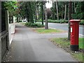
Queen?s Park: postbox № BH8 248, Queen?s Park Avenue
Here we are looking along the western section of Queen's Park Avenue, which has trees and houses on both sides – further east the golf course abuts the southern side. The postbox, an Edward VII-reign specimen, is outside number 26.
Image: © Chris Downer
Taken: 1 Jul 2008
0.07 miles
2
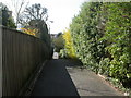
Charminster: footpath K01 reaches Ashling Crescent
This public footpath from Charminster Road has headed quite steeply uphill but flattens out for these last few yards as it reaches its destination.
See Image for the view towards us from ahead, and Image for the next view behind us, with links to further photos on the path.
Image: © Chris Downer
Taken: 25 Feb 2017
0.09 miles
3
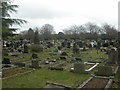
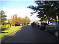
Bournemouth North Cemetery
Most of the gravestones in this section date from the 1940s. The cemetery has been Natural Death regional winner for several years.http://www.naturaldeath.org.uk/awards.html
Image: © Mike Faherty
Taken: 3 Mar 2009
0.09 miles
4

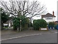
Crematorium and North Cemetery
This is situated on Strouden Avenue, North Bournemouth.
Image: © Stuart Buchan
Taken: 28 May 2006
0.10 miles
5
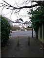
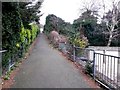
Charminster: footpath K01 from Ashling Crescent
This public footpath leads down to Charminster Road, saving a fair detour compared with the road route.
See Image for the next view on the path, with links to further photos on the path.
Image: © Chris Downer
Taken: 25 Feb 2017
0.10 miles
6
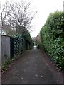
Charminster, footpath
Short footpath from Ashling Close to Charminster Road near Five Ways, showing the descent into the valley of Charminster Road.
Image: © Mike Faherty
Taken: 28 Mar 2009
0.10 miles
7
North Cemetery
The view in Bournemouth North Cemetery.
Image: © Gordon Griffiths
Taken: 26 Oct 2016
0.12 miles
8
Charminster: footpath K01 heads downhill
This public footpath from Ashling Crescent is more or less level for the first few yards, but then descends at a moderately steep gradient towards Charminster Road.
See Image for the next view on the path ahead, and Image for the next view behind us - each with links to further photos on the path.
Image: © Chris Downer
Taken: 25 Feb 2017
0.12 miles
9
Charminster: ascending footpath K01
While the rear driveway for Queen's Court, just to our right, heads downhill from street level just behind us, this public footpath goes quite steeply uphill on its way to Ashling Crescent.
See Image for the view onto Charminster Road behind us, and Image for the next view on the path ahead, with links to further photos on the path.
Image: © Chris Downer
Taken: 25 Feb 2017
0.12 miles
10
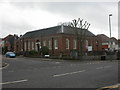
Charminster Library
Library at the junction of Charminster Road & Strouden Avenue, built 1932. For services offered, see http://www.bournemouth.gov.uk/Residents/Libraries/Info/charminster2.asp
Image: © Mike Faherty
Taken: 3 Mar 2009
0.12 miles