IMAGES TAKEN NEAR TO
Charminster Road, BOURNEMOUTH, BH8 8SJ
Introduction
This page details the photographs taken nearby to Charminster Road, BH8 8SJ by members of the Geograph project.
The Geograph project started in 2005 with the aim of publishing, organising and preserving representative images for every square kilometre of Great Britain, Ireland and the Isle of Man.

There are currently over 7.5m images from over14,400 individuals and you can help contribute to the project by visiting https://www.geograph.org.uk
Image Map (Loading...)


Getting Data...Please wait
Leaflet Map data © OpenStreetMap
Images are licensed for reuse under creativecommons.org/licenses/by-sa/2.0
Notes
- Clicking on the map will re-center to the selected point.
- The higher the marker number, the further away the image location is from the centre of the postcode.
Image Listing (89 Images Found)
Images are licensed for reuse under creativecommons.org/licenses/by-sa/2.0
Image
Details
Distance
1
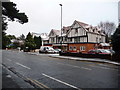
Charminster: Quest House
This used to be the 'Quest House International Hotel' but was converted to flats about five years ago. It retains the name Quest House and, I believe, the original signboard, albeit with the International Hotel bit removed.
Image: © Chris Downer
Taken: 6 Feb 2009
0.02 miles
2
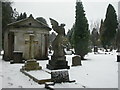
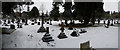
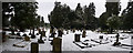
Bournemouth, Wimborne Road Cemetery
Neo-Classical mausoleum to the Doyles and surrounding graves, snug in a blanket of snow. For more pictures of the cemetery, see http://www.suzielda.co.uk/netcemy/cemy/bour/bour.htm
Image: © Mike Faherty
Taken: 6 Feb 2009
0.03 miles
3
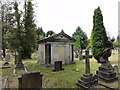
Cemetery Tomb
Tomb with the name DOYLE above the sealed door within the cemetery.
Image: © Mat Tuck
Taken: 26 Jul 2013
0.04 miles
4
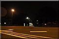
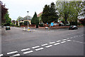
Bournemouth : Charminster Road Roundabout
A roundabout where Charminster Road meets Wellington Road.
Image: © Lewis Clarke
Taken: 5 Oct 2010
0.05 miles
5
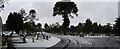
Bournemouth : Wimborne Road Cemetery
Snow covers the gravestones and burial patches of the cemetery.
Image: © Lewis Clarke
Taken: 6 Feb 2009
0.05 miles
6
Junction: Portchester Road and Milton Road
The blue board belongs to The Corner House day nursery.
Image: © Kris
Taken: 6 May 2006
0.07 miles
7
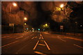
Bournemouth : Charminster Road B3063
The road heading towards the junction with Wimborne Road near the cemetery.
Image: © Lewis Clarke
Taken: 5 Oct 2010
0.07 miles
8
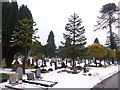
Bournemouth: Wimborne Road Cemetery
This large cemetery, which gives its name to Image at its southern corner, has been hit by today's snowfall.
Two days after heavy snow earlier in the week had all thawed, this fresh lot fell from the north this morning, despite the fact that the day started rainy, with large puddles all around.
By nightfall, the main carriageways of all roads were clear of snow and ice, so this was a very heavy fall considering that it started and had almost disappeared on the same day.
Image: © Chris Downer
Taken: 6 Feb 2009
0.07 miles
9
Bournemouth : Wimborne Road Cemetery
A snowy day at the cemetery.
Image: © Lewis Clarke
Taken: 6 Feb 2009
0.08 miles
10
Bournemouth : Wimborne Road Cemetery
Snow came suddenly to Bournemouth on this day. I woke up and didn't expect that come the afternoon it would be as white as this.
Image: © Lewis Clarke
Taken: 6 Feb 2009
0.08 miles