IMAGES TAKEN NEAR TO
Stewart Road, BOURNEMOUTH, BH8 8NX
Introduction
This page details the photographs taken nearby to Stewart Road, BH8 8NX by members of the Geograph project.
The Geograph project started in 2005 with the aim of publishing, organising and preserving representative images for every square kilometre of Great Britain, Ireland and the Isle of Man.

There are currently over 7.5m images from over14,400 individuals and you can help contribute to the project by visiting https://www.geograph.org.uk
Image Map
Images are licensed for reuse under creativecommons.org/licenses/by-sa/2.0
Notes
- Clicking on the map will re-center to the selected point.
- The higher the marker number, the further away the image location is from the centre of the postcode.
Image Listing (34 Images Found)
Images are licensed for reuse under creativecommons.org/licenses/by-sa/2.0
Image
Details
Distance
1
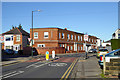
Corner block, Bennett Road and Stewart Road
This seems entirely residential now, but once had shop fronts along Bennett Road.
Image: © Robin Webster
Taken: 25 Nov 2016
0.06 miles
2
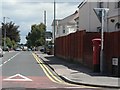
Malmesbury Park: postbox № BH8 46, Bennett Road
Looking along Bennett Road from the Stewart Road junction, with this Edward VII-reign postbox on the right.
Image: © Chris Downer
Taken: 19 Jul 2008
0.07 miles
3
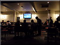
Malmesbury Park: the Brunswick smoking area
The Image has produced a novel solution to the ban on smoking in enclosed public spaces, which came into force in July 2007.
This courtyard has been built, which looks for all the world like it is an interior space, complete with fire and hearth, and large screen tv. In fact, the 'ceiling' is in fact merely a canopy and we are viewing from a table open to the elements.
Image: © Chris Downer
Taken: 25 Aug 2012
0.09 miles
4

Malmesbury Park: The Brunswick and St. Leonard?s Road
Image is dated 1883 above the right-hand window, and contrasts with the majority of the roads around here (see Image). It is on the corner of Malmesbury Park Road and St. Leonard’s Road, from which latter this picture was taken.
Image: © Chris Downer
Taken: 1 Jan 2008
0.09 miles
5

Malmesbury Park: The Brunswick
The Brunswick is a pub in Malmesbury Park Road, and is dated 1883 in the right-hand gable. It has had a recent facelift, particularly in the rear area, where toilets have been replaced and a large beer-garden installed, much of which is covered and has pictures hanging making it look like an interior room (see Image). This surmounts the challenge of the smoking ban which came into force on 1 July last year.
The cars on the forecourt are probably those of drinkers who saw the new year in here last night. I collected mine, which was parked a few doors away, just now.
Image: © Chris Downer
Taken: 1 Jan 2008
0.09 miles
6
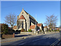
St. Andrew's church, Bournemouth
In the Charminster area, on Bennett Road.
Image: © Robin Webster
Taken: 25 Nov 2016
0.12 miles
7
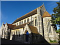
St Andrews Church
The South Cross is an Ordnance Survey Triangulation point, http://www.trigpointinguk.com/trigs/trig-details.php?t=9332
Image: © Mat Tuck
Taken: 26 Jul 2013
0.12 miles
8
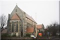
Malmesbury Park: parish church of St. Andrew
Image: © Chris Downer
Taken: Unknown
0.12 miles
9
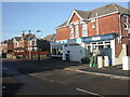
Winton, corner shops
Much of Winton is late Victorian, and built on a typical grid pattern, with shops on many corners. Most of these have been converted to other uses, and disappeared. An exception is this group of three shops, on the corner of Shelbourne & St Leonards Roads. Nearest to the camera, a food/convenience store, then a plastics supplier (at one time, at least), then a bike shop, obviously tapping into the local student population.
Image: © Mike Faherty
Taken: 17 Dec 2008
0.15 miles
10
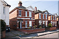
Bournemouth - 175, Capstone Road
The former home of Corporal Cecil Reginald Noble VC (1891 - 1915) one of two posthumously awarded recipients of the Victoria Cross during WWI who lived in the same street. He was fatally wounded at Neuve Chapelle in 1915.
Image
Image: © Mike Searle
Taken: 9 Apr 2015
0.16 miles