IMAGES TAKEN NEAR TO
Chelsea Gardens, BOURNEMOUTH, BH8 8FE
Introduction
This page details the photographs taken nearby to Chelsea Gardens, BH8 8FE by members of the Geograph project.
The Geograph project started in 2005 with the aim of publishing, organising and preserving representative images for every square kilometre of Great Britain, Ireland and the Isle of Man.

There are currently over 7.5m images from over14,400 individuals and you can help contribute to the project by visiting https://www.geograph.org.uk
Image Map
Images are licensed for reuse under creativecommons.org/licenses/by-sa/2.0
Notes
- Clicking on the map will re-center to the selected point.
- The higher the marker number, the further away the image location is from the centre of the postcode.
Image Listing (92 Images Found)
Images are licensed for reuse under creativecommons.org/licenses/by-sa/2.0
Image
Details
Distance
1
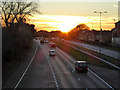
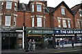
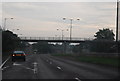
Sunset, Bournemouth
Strictly speaking, ten minutes before sunset. A view along the A338, Wessex Way, the main approach road to central Bournemouth.
Image: © Robin Webster
Taken: 25 Nov 2016
0.02 miles
2
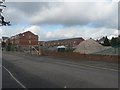
A site for sore eyes ? and other nauseous complaints
This is the building site of the old Wilkins Bakery, which had lain derelict for years and has recently been demolished to make way for homes. The large pile of resultant rubble has recently been roughly halved in size (lengthways) to what you see in this image. Local residents complained of ill-health as a result of this huge eyesore which had been bigger than their houses. The local paper, the Bournemouth Echo, reported it here: http://www.bournemouthecho.co.uk/search/display.var.1537371.0.rubble_and_strife.php
Image: © Chris Downer
Taken: 23 Sep 2007
0.03 miles
3
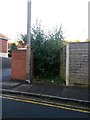
Malmesbury Park: footpath D07 to nowhere
A rather stumpy public right of way proceeds 14m from Henville Road, whereupon it just stops. It did have a purpose before the roads here were realigned and severed to make way for the main A338 in the 1970s: Henville Road was previously a Y-shaped road, and this path cut the corner off within the centre junction of the 'Y'. Today, it is overgrown for about 13 of its 14-metre length, and as such is barely navigable even if there was some purpose for doing so. Needless to say, I didn't attempt to walk along it just now.
It also appears to have become something of a litter repository.
Image: © Chris Downer
Taken: 23 Jun 2016
0.06 miles
4

Malmesbury Park: footpath D08 from Shelbourne Road
A short alleyway connects two long, parallel streets, Shelbourne Road and Capstone Road, and we are looking at it here from the former. It also nowadays forms a driveway to small chalet houses that have been built in people's back gardens - the distant one to the left and two similar ones, one on each side of the path behind it.
See Image for the next view along the path, with links to other photos.
Image: © Chris Downer
Taken: 28 Jul 2016
0.08 miles
5

Malmesbury Park: footpath D08 heads for Shelbourne Road
A short alleyway connects two long, parallel streets, Shelbourne Road and Capstone Road, and we are approaching the former. It also nowadays forms a driveway to two small chalet houses that have been built in the back gardens of Capstone Road and one, just to our right, in a Shelbourne Road back garden.
See Image for the view behind us, and Image for the next photo towards us from the road ahead.
Image: © Chris Downer
Taken: 28 Jul 2016
0.08 miles
6
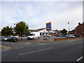
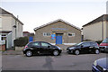
Springbourne, Aldi
Supermarket on Holdenhurst Road.
Image: © Mike Faherty
Taken: 12 Sep 2012
0.08 miles
10
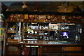
The Scottish Hall, Shelbourne Road, Bournemouth
Home of the Bournemouth Caledonian Society.
Image: © Robin Webster
Taken: 25 Nov 2016
0.09 miles