IMAGES TAKEN NEAR TO
Holdenhurst Road, BOURNEMOUTH, BH8 8BL
Introduction
This page details the photographs taken nearby to Holdenhurst Road, BH8 8BL by members of the Geograph project.
The Geograph project started in 2005 with the aim of publishing, organising and preserving representative images for every square kilometre of Great Britain, Ireland and the Isle of Man.

There are currently over 7.5m images from over14,400 individuals and you can help contribute to the project by visiting https://www.geograph.org.uk
Image Map
Images are licensed for reuse under creativecommons.org/licenses/by-sa/2.0
Notes
- Clicking on the map will re-center to the selected point.
- The higher the marker number, the further away the image location is from the centre of the postcode.
Image Listing (101 Images Found)
Images are licensed for reuse under creativecommons.org/licenses/by-sa/2.0
Image
Details
Distance
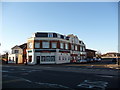
1

Former St Mary Springbourne
Erected in 1926. Now used as the Bourne Spring Centre.
Image: © Michael FORD
Taken: Unknown
0.02 miles
3
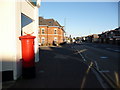
Springbourne: postbox № BH8 106, Holdenhurst Road
This postbox stands outside Image The structure on its top is the remains of a post office direction sign – the old post office is discussed in the above link.
Image: © Chris Downer
Taken: 26 Dec 2008
0.06 miles
4
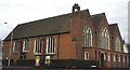
Springbourne: former parish church of St. Mary
This church has fairly recently been deconsecrated and is now being used as a community centre.
Image: © Chris Downer
Taken: Unknown
0.06 miles
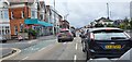
5
Springbourne: shops on the old gyratory
This shops were in the centre of a gyratory system until the late 1980s when the roundabout junction was installed. The one alongside Ladbroke's was Holdenhurst Road East Post Office until its closure on 9 February 2004. It briefly retained retail use as an athletics supplier, but has now been converted to residential use.
Image: © Chris Downer
Taken: 26 Dec 2008
0.07 miles
6
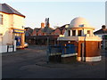
Bournemouth East Conservative Club and St Pauls Toilets
Holdenhurst Road Shelbourne Close Junction
Image: © Wilf Vernon
Taken: 17 May 2003
0.08 miles
7

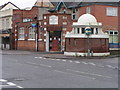
Gents' Convenience, Springbourne
This loo, the "Pepperpot", is on Holdenhurst Road, Springbourne; one of 89 listed by English Heritage. Built about 1905; entrance should be at the back, down steps to beneath the street. English Heritage describes it as "a witty and carefully detailed solution to a utilitarian structure", but unfortunately it is firmly padlocked; it is also not obvious what facilities there were for ladies!
Image: © Mike Faherty
Taken: 22 Oct 2008
0.08 miles
8
Facilities outside the club
A small, underground, public conveniences stand at the road junction close to the Bournemouth East Conservative Club. The toilets opened in 1905 but closed in 2017. It was then offered on the market for a mere £25,000 for repurposing. The Grade II listed structure has a concrete domed roof with access via a single entrance down a staircase. It is brick-built, fitted with Crittal windows and is believed to have water, mains electricity and gas available inside. The flower bags on the top seem to indicate it has new owners.
Image: © Neil Owen
Taken: 22 Jun 2022
0.08 miles
9

Springbourne Fire Station
Springbourne Fire Station, Richmond Park Close, Bournemouth, Dorset is situated on a busy roundabout, and is one of the 3 fire stations that cover Bournemouth.
Image: © Kevin Hale
Taken: 27 Sep 2006
0.08 miles
10
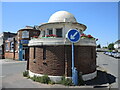
Springbourne: the listed loo
These gents' toilets, in a traffic island of Shelbourne Close, sadly, have been closed for a few years now. They are sort of semi-underground, accessed by this short staircase. It is a listed building and, apparently, locally known as the 'Cathedral of Springbourne', although I have never heard it referred to as such.
Image: © Chris Downer
Taken: 28 Dec 2008
0.09 miles