IMAGES TAKEN NEAR TO
Cheshire Gardens, BOURNEMOUTH, BH8 0FD
Introduction
This page details the photographs taken nearby to Cheshire Gardens, BH8 0FD by members of the Geograph project.
The Geograph project started in 2005 with the aim of publishing, organising and preserving representative images for every square kilometre of Great Britain, Ireland and the Isle of Man.

There are currently over 7.5m images from over14,400 individuals and you can help contribute to the project by visiting https://www.geograph.org.uk
Image Map (Loading...)


Getting Data...Please wait
Leaflet Map data © OpenStreetMap
Images are licensed for reuse under creativecommons.org/licenses/by-sa/2.0
Notes
- Clicking on the map will re-center to the selected point.
- The higher the marker number, the further away the image location is from the centre of the postcode.
Image Listing (34 Images Found)
Images are licensed for reuse under creativecommons.org/licenses/by-sa/2.0
Image
Details
Distance
1
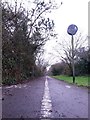
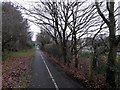
Townsend: dividing line on footpath K45
This public footpath, nowadays marked out as a shared foot/cycle route, runs for 500m or so alongside the main A338 and is essentially a replacement for this segment of Holdenhurst Road, which was lost to make way for the dual carriageway. Holdenhurst Road is still one of the town's main routes but no longer reaches Holdenhurst village as it originally did.
Here, the camera is positioned low to the ground as we look along the white line separating the intended cycle and walking halves of the paved path.
See Image for the next view on the path ahead, and Image for the next view behind us - each with links to further photos along the route.
Image: © Chris Downer
Taken: 8 Jan 2017
0.09 miles
2
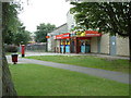
One-Stop shop, North Bournemouth
This shop/post office is found between Strouden and Holdenhurst.
Image: © Stuart Buchan
Taken: 1 Aug 2005
0.09 miles
3
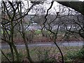
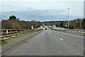
Townsend: view across footpath K45 and the Spur Road
This public footpath, nowadays marked out as a shared foot/cycle route, runs for 500m or so alongside the main A338 and is essentially a replacement for this segment of Holdenhurst Road, which was lost to make way for the dual carriageway. Holdenhurst Road is still one of the town's main routes but no longer reaches Holdenhurst village as it originally did.
Here, we look across the path from a steep bank separating it from a public green space. The view extends across the A338 Spur Road at the point where a slip road joins the main carriageway (see the thick white markings at the extreme right-hand edge of the picture).
See Image for the next view on the path to the left, and Image for the next view to the right - each with links to further photos along the route.
Image: © Chris Downer
Taken: 8 Jan 2017
0.09 miles
5
Townsend: footpath K45 alongside the Spur Road
This public footpath, nowadays marked out as a shared foot/cycle route, runs for 500m or so alongside the main A338 and is essentially a replacement for this segment of Holdenhurst Road, which was lost to make way for the dual carriageway. Holdenhurst Road is still one of the town's main routes but no longer reaches Holdenhurst village as it originally did.
Here, we look eastward along the path and can see the main A338, known as the Spur Road, through the trees to the right. We are just alongside the point where the northbound on-slip starts to join the main carriageway.
See Image for the next view on the path ahead, and Image for the next view behind us - each with links to further photos along the route.
Image: © Chris Downer
Taken: 8 Jan 2017
0.11 miles
6
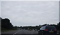
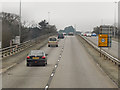
A338 Wessex Way, northbound
Descending from the overbridge at the junction with the A3060.
Image: © Robin Webster
Taken: 1 Apr 2018
0.12 miles
7
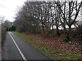
Townsend: footpath K45 and a glimpse of Cheshire Drive houses
This public footpath, nowadays marked out as a shared foot/cycle route, runs for 500m or so alongside the main A338 and is essentially a replacement for this segment of Holdenhurst Road, which was lost to make way for the dual carriageway. Holdenhurst Road is still one of the town's main routes but no longer reaches Holdenhurst village as it originally did.
Here, we look towards the western end of the path, with the backs of houses of Cheshire Drive visible to the right - they are beyond a strip of public green space the other side of the trees.
See Image for the next view on the path ahead, and Image for the next view behind us - each with links to further photos along the route.
Image: © Chris Downer
Taken: 8 Jan 2017
0.12 miles
8
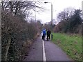
Townsend: dog walkers meet on footpath K45
This public footpath, nowadays marked out as a shared foot/cycle route, runs for 500m or so alongside the main A338 and is essentially a replacement for this segment of Holdenhurst Road, which was lost to make way for the dual carriageway. Holdenhurst Road is still one of the town's main routes but no longer reaches Holdenhurst village as it originally did.
Here, we look along the path just as two dog walkers, with five dogs between them, stop to chat about a quarter of the way along the path.
See Image for the next view on the path ahead, and Image for the next view behind us - each with links to further photos along the route.
Image: © Chris Downer
Taken: 8 Jan 2017
0.12 miles
10
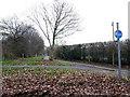
Townsend: footpath K45 from Throop Road
This public footpath, nowadays marked out as a shared foot/cycle route, runs for 500m or so alongside the main A338 and is essentially a replacement for this segment of Holdenhurst Road, which was lost to make way for the dual carriageway. Holdenhurst Road is still one of the town's main routes but no longer reaches Holdenhurst village as it originally did.
Here, we look along the path from the dead end of Throop Road, which likewise used to continue right until the 1960s when the A338 was built.
See Image for the view towards us from just ahead, and Image for the next view on the path ahead, with links to further photos along the route.
Image: © Chris Downer
Taken: 8 Jan 2017
0.13 miles