IMAGES TAKEN NEAR TO
Throop Road, BOURNEMOUTH, BH8 0DJ
Introduction
This page details the photographs taken nearby to Throop Road, BH8 0DJ by members of the Geograph project.
The Geograph project started in 2005 with the aim of publishing, organising and preserving representative images for every square kilometre of Great Britain, Ireland and the Isle of Man.

There are currently over 7.5m images from over14,400 individuals and you can help contribute to the project by visiting https://www.geograph.org.uk
Image Map
Images are licensed for reuse under creativecommons.org/licenses/by-sa/2.0
Notes
- Clicking on the map will re-center to the selected point.
- The higher the marker number, the further away the image location is from the centre of the postcode.
Image Listing (39 Images Found)
Images are licensed for reuse under creativecommons.org/licenses/by-sa/2.0
Image
Details
Distance
2
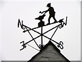
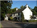
Weather vane, The Old Forge
As long as humans have farmed the land, sailed the seas and contemplated their place in nature, the wind has played a key role in their speculations. It was interpreting the wind's changing direction that helped our ancestors predict the coming weather and survive.
Image: © Maigheach-gheal
Taken: 21 Feb 2011
0.03 miles
3
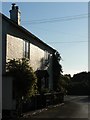
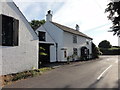
Holdenhurst: old forge and postbox
Image: © Chris Downer
Taken: 15 Jul 2008
0.03 miles
4
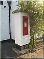
Holdenhurst: postbox № BH8 271, Holdenhurst Village Road
This postbox stands outside Image
Image: © Chris Downer
Taken: 15 Jul 2008
0.03 miles
5
Holdenhurst: old forge and old post office
This cottage is called the Old Forge, but is also the former post office. It closed on 18 October 1975 but was effectively replaced by Image which opened on 8 November 1983.
Image: © Chris Downer
Taken: 15 Jul 2008
0.03 miles
6
The Old Forge
On the junction of Holdenhurst Village Road and Throop Road. Royal Mail post box in a brick pillar.
Image: © Mat Tuck
Taken: 26 Jul 2013
0.04 miles
7
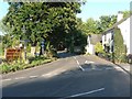
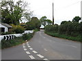
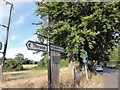
Holdenhurst: the only road to the village
Image: © Chris Downer
Taken: 15 Jul 2008
0.05 miles
8
Holdenhurst: Holdenhurst Village Road
This road has recently been renamed Holdenhurst Village Road, having previously been without the 'Village'.
The reason is that Holdenhurst Road, which ran from Bournemouth town centre to this point, is now cut off about a mile southwest – the section from the town is a busy, major road, whereas this part is a country lane that leads only to Holdenhurst Village. This had caused problems with motorists using satellite navigation, who found themselves in the pleasant but dead-end village, and if they were in anything large could not turn round!
In the distance are Image
Image: © Chris Downer
Taken: 15 Jul 2008
0.05 miles
9
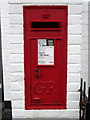
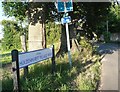
Postbox near Throop
George V reign postbox set into the wall of the Old Forge.
Image: © Maigheach-gheal
Taken: 21 Feb 2011
0.05 miles
10
Holdenhurst Village Road
Road scene with gas lamp.
Image: © Mat Tuck
Taken: 26 Jul 2013
0.06 miles