IMAGES TAKEN NEAR TO
Littledown Drive, BOURNEMOUTH, BH7 7AQ
Introduction
This page details the photographs taken nearby to Littledown Drive, BH7 7AQ by members of the Geograph project.
The Geograph project started in 2005 with the aim of publishing, organising and preserving representative images for every square kilometre of Great Britain, Ireland and the Isle of Man.

There are currently over 7.5m images from over14,400 individuals and you can help contribute to the project by visiting https://www.geograph.org.uk
Image Map
Images are licensed for reuse under creativecommons.org/licenses/by-sa/2.0
Notes
- Clicking on the map will re-center to the selected point.
- The higher the marker number, the further away the image location is from the centre of the postcode.
Image Listing (44 Images Found)
Images are licensed for reuse under creativecommons.org/licenses/by-sa/2.0
Image
Details
Distance
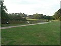
3
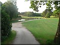
Queen?s Park: Longman?s Bottom
This path is thought to be an ancient thoroughfare, but it has gone through the middle of the golf course now for about 100 years. The golf course, one of two municipal courses in the borough of Bournemouth, is a public open space.
Clearly visible in the centre is Image
Image: © Chris Downer
Taken: 11 May 2008
0.09 miles
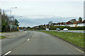
4
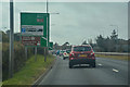
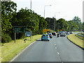
Bournemouth : Wessex Way A338
Heading into Bournemouth on the Wessex Way.
Image: © Lewis Clarke
Taken: 27 Mar 2018
0.09 miles
5
Queen?s Park: the pond
A little pond in the middle of Queen’s Park golf course.
Image: © Chris Downer
Taken: 11 May 2008
0.11 miles
7
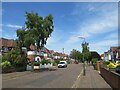
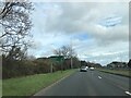
William Road, Littledown, Bournemouth
William Road is a residential road in Littledown, in the north-eastern suburbs of Bournemouth.
Image: © Malc McDonald
Taken: 21 Jun 2022
0.12 miles
8
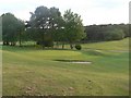
Queen?s Park: across Longman?s Bottom
Queen’s Park was left to the Council about 100 years ago, for the public to use for leisure. The Council installed the golf course but it remains a public open space available for whatever leisure pursuit takes your fancy. Here, we look across Image path.
Image: © Chris Downer
Taken: 11 May 2008
0.12 miles
9
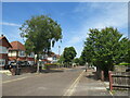
William Road, Littledown, Bournemouth
William Road is a residential road in Littledown, in the north-eastern suburbs of Bournemouth.
Image: © Malc McDonald
Taken: 21 Jun 2022
0.13 miles
10
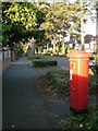
Littledown: postbox № BH7 244, Littledown Avenue
A George V-reign postbox at the southern end of this road of very desirable residences.
Image: © Chris Downer
Taken: 13 Jul 2008
0.13 miles