IMAGES TAKEN NEAR TO
Rebbeck Road, BOURNEMOUTH, BH7 6LP
Introduction
This page details the photographs taken nearby to Rebbeck Road, BH7 6LP by members of the Geograph project.
The Geograph project started in 2005 with the aim of publishing, organising and preserving representative images for every square kilometre of Great Britain, Ireland and the Isle of Man.

There are currently over 7.5m images from over14,400 individuals and you can help contribute to the project by visiting https://www.geograph.org.uk
Image Map (Loading...)


Getting Data...Please wait
Leaflet Map data © OpenStreetMap
Images are licensed for reuse under creativecommons.org/licenses/by-sa/2.0
Notes
- Clicking on the map will re-center to the selected point.
- The higher the marker number, the further away the image location is from the centre of the postcode.
Image Listing (129 Images Found)
Images are licensed for reuse under creativecommons.org/licenses/by-sa/2.0
Image
Details
Distance
2
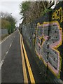
Pokesdown: lots of yellow on Hannington Place
Hannington Place is a public footpath, number G04, and also a driveway to a few properties, which runs from Christchurch Road, turns to run alongside the railway line and comes out at the dead end of York Place. The longer straight, abutting the railway, has been tarmacked in fairly recent years, having been a gravel drive previously.
Here, we look along it as it runs alongside the railway - the road markings and this particular patch of graffiti make for quite a yellow scene.
See Image for the next view on the path ahead, and Image for the next view behind us - each with links to further photos along the routes.
Image: © Chris Downer
Taken: 25 Feb 2017
0.08 miles
3
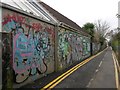
Pokesdown: graffitied walls on Hannington Place
Hannington Place is a public footpath, number G04, and also a driveway to a few properties, which runs from Christchurch Road, turns to run alongside the railway line and comes out at the dead end of York Place. The longer straight, abutting the railway, has been tarmacked in fairly recent years, having been a gravel drive previously.
Here, we look along it as it runs alongside the railway towards a distant York Place - graffiti is something of a feature along here and few vertical surfaces have escaped it.
See Image for the next view on the path ahead, and Image for the next view behind us - each with links to further photos along the routes.
Image: © Chris Downer
Taken: 25 Feb 2017
0.08 miles
4
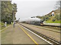
Pokesdown, Flying Scotsman
Steaming through Pokesdown Station, for a few days' light duties by the seaside in Swanage: http://www.realtimetrains.co.uk/train/U52018/2019/03/19/advanced https://swanagerailway.co.uk/events/detail/flying-scotsman-running-days
Image: © Mike Faherty
Taken: 19 Mar 2019
0.08 miles
5
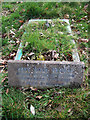
A wartime tragedy, and the death of baby Jane - a Bournemouth (East) Cemetery grave (1)
-
A chance discovery of a child's grave in Bournemouth East Cemetery http://www.geograph.org.uk/photo/2883110 with its poignant headstone inscription, led me to investigate the circumstances that led to the sudden death of its occupant, a 5 month old baby girl. Jane Ann Pearce age 5 months was a casualty of war who was killed as a result of enemy action in Bournemouth in 1940. The headstone inscription is at slight odds with the subsequently discovered facts, the names are 'Pearce' not 'Pearse', and Ann rather than Anne. Also, the date of death occurred not on 10th November, but on the night of the 9th.
Although faring better than most large towns, Bournemouth was nevertheless visited by the Luftwaffe on many occasions throughout the Second World War when a total of more than 2,200 bombs were dropped on the town. The first of these raids occurred in July 1940 and continued sporadically throughout the remainder of that year, and indeed for the rest of the war. The raid that killed baby Jane occurred at 22.15 hrs on the night of 9th November 1940, when a lone aircraft dropped a stick of 10 H.E. bombs in the Knyveton Road area. The bombs severely damaged or destroyed two properties in Spencer Road killing four people including baby Jane, and seriously injuring two others. Those killed were Jane Ann Pearce, the 5 month old daughter of a Captain Denham Pearce at no. 29, and at no. 19, James Mitchell age 69, his wife Fanny Jane Mitchell age 68, and Lily Mugg age 47.
Although it's sad to see that the grave of baby Jane is not being maintained, it is perhaps worth pointing out that the graves of civilian casualties are not normally the responsibility of the Commonwealth War Graves Commission. The organisation does however commemorate all civilian war deaths due to enemy action throughout 1939-1945, in the Civilian War Dead Roll of Honour, located near St. George's Chapel in Westminster Abbey.
The CWGC Memorial to Jane Ann Pearce: https://www.cwgc.org/find-war-dead/casualty/3111088/pearce,-jane-ann/
Image
Image: © Mike Searle
Taken: 9 Mar 2017
0.08 miles
6
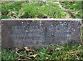
A wartime tragedy, and the death of baby Jane - a Bournemouth (East) Cemetery grave (2)
-
The memorial inscription. The spelling of the name and the date of death is slightly at odds with the official record. The name is officially recorded as 'Jane Ann Pearce' and the date of death 9th November.
Image
Image: © Mike Searle
Taken: 9 Mar 2017
0.08 miles
7
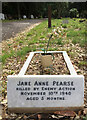
A wartime tragedy, and the death of baby Jane - a Bournemouth (East) Cemetery grave (5)
2022 Update: The grave has since been renovated, the stone cleaned, and the inscription renewed.
_____
Image
Image: © Mike Searle
Taken: 28 Aug 2022
0.08 miles
8
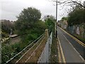
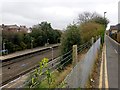
Pokesdown: Hannington Place and the end of the station platforms
Hannington Place is a public footpath, number G04, and also a driveway to a few properties, which runs from Christchurch Road, turns to run alongside the railway line and comes out at the dead end of York Place. The longer straight, abutting the railway, has been tarmacked in fairly recent years, having been a gravel drive previously.
Here, we look along it as it runs alongside the railway - Pokesdown station has particularly long platforms and by the time we reach this western extremity, the canopy has long come to an end.
See Image for the next view on the path ahead, and Image for the next view behind us - each with links to further photos along the routes.
Image: © Chris Downer
Taken: 25 Feb 2017
0.08 miles
9
Pokesdown: Hannington Place and the station platforms
Hannington Place is a public footpath, number G04, and also a driveway to a few properties, which runs from Christchurch Road, turns to run alongside the railway line and comes out at the dead end of York Place. The longer straight, abutting the railway, has been tarmacked in fairly recent years, having been a gravel drive previously.
Here, we look along it as it runs alongside Pokesdown Station - it has particularly long platforms and the canopy has stopped by the time we reach their western extremities.
See Image for the next view on the path ahead, and Image for the next view behind us - each with links to further photos along the routes.
Image: © Chris Downer
Taken: 25 Feb 2017
0.09 miles