IMAGES TAKEN NEAR TO
Gloucester Road, BOURNEMOUTH, BH7 6JF
Introduction
This page details the photographs taken nearby to Gloucester Road, BH7 6JF by members of the Geograph project.
The Geograph project started in 2005 with the aim of publishing, organising and preserving representative images for every square kilometre of Great Britain, Ireland and the Isle of Man.

There are currently over 7.5m images from over14,400 individuals and you can help contribute to the project by visiting https://www.geograph.org.uk
Image Map
Images are licensed for reuse under creativecommons.org/licenses/by-sa/2.0
Notes
- Clicking on the map will re-center to the selected point.
- The higher the marker number, the further away the image location is from the centre of the postcode.
Image Listing (93 Images Found)
Images are licensed for reuse under creativecommons.org/licenses/by-sa/2.0
Image
Details
Distance
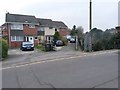
1
Boscombe, Kings Park Hospital
Off Gloucester Road, with other buildings out of sight; providing in- and outpatient mental healthcare: http://www.nhs.uk/Services/hospitals/Overview/DefaultView.aspx?id=2539
Image: © Mike Faherty
Taken: 25 Jun 2011
0.01 miles
2
Bournemouth East Cemetery, mortuary
On the main drive from Gloucester Road is this public mortuary, not quite screened off from view by holly trees. Built in 1960s style concrete, almost brutalist, and quite out of keeping with the Victorian character of the cemetery.
Image: © Mike Faherty
Taken: 25 Oct 2008
0.05 miles
4
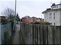
Boscombe: footpath F06 arrives on Gloucester Road
Looking along the final stretch of this public footpath from Wolverton Road as it arrives at its destination. This final leg of the path abuts the railway line, left.
See Image for the view towards us from across the road, and Image for the next view on the path behind, with links to further photos on the route.
Image: © Chris Downer
Taken: 11 Feb 2017
0.07 miles
5
Boscombe: footpath F06 from Gloucester Road
A narrow alley forms a public footpath to Wolverton Road, starting off alongside the railway line before turning left ahead.
See Image for the view towards us from along the path, with links to further photos on the route.
Image: © Chris Downer
Taken: 11 Feb 2017
0.07 miles
6
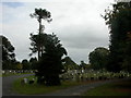
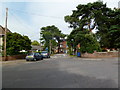
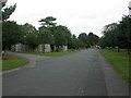
Bournemouth East Cemetery
Opened in the 1890s. Contains many trees, mainly evergreen. The monkey puzzles on the left have had a close shave! Picture taken from main drive from Gloucester Road.
Image: © Mike Faherty
Taken: 25 Oct 2008
0.08 miles
7
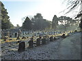
A frosty morning in Boscombe East Cemetery
Image: © Rod Allday
Taken: 21 Jan 2023
0.08 miles
8

Pilot Officer C H Hight - a tribute: Commonwealth War Grave, Bournemouth East Cemetery (1)
†
The 75th anniversary of the Battle of Britain is an appropriate time to remember the only Allied airman killed in action over Bournemouth during the Battle. Pilot Officer Cecil Henry Hight was a New Zealander who in 1938 had worked his passage to England in order to join the RAF as a pilot. After completion of flying training in November 1939, he joined 234 Squadron at Leconfield, flying Blenheims, although by March 1940 the squadron had been re-equipped with Spitfires. On Thursday 15 August 1940 in the middle of the Battle of Britain, 234 Squadron Spitfires, then based at Middle Wallop in Hampshire were scrambled to intercept a large formation of German bombers and fighter escort spotted off Portland in Dorset.
During the engagement P/O Hight's Spitfire, R6988 was hit over Bournemouth by machine gun fire from the rear gunner of a German bomber. Eye-witnesses reported his aircraft going down into a dive from about 5000 feet, followed by the pilot who had managed to bail out but whose parachute failed to open. The body of P/O Hight was recovered from the garden of 'Hambledon' a house in Leven Avenue; his aircraft crashed nearby at the corner of Leven Avenue and Walsford Road, barely 50 yards away. It is thought that Hight was too badly injured to pull the 'D' ring of his parachute ripcord. He was buried with full military honours in Bournemouth East Cemetery (Boscombe), on 19 August. A memorial service was held in St Peter's church, Bournemouth on 7 April 1943, and a plaque to Hight's memory who was aged just 22 when he died, was unveiled in the church by the High Commissioner for New Zealand.
Mr and Mrs Hoare the owners of 'Hambledon' planted a Garden of Remembrance on the spot where Hight's body was found. Tragically, three months later Mr Hoare was killed, and his wife buried in the debris of their house when it was destroyed in another bombing raid. No trace of the house or its Garden of Remembrance remains today.
After the war a housing estate road in West Howe, Bournemouth was named Pilot Hight Road in memory of the young airman, and an image of a Spitfire was added to two of the road signs in 2010 as a further tribute. In 2015, the 75th anniversary year of the Battle of Britain, and on the 75th anniversary of Hight's death, a Portland stone memorial was unveiled at Leven Avenue by Bournemouth Mayor John Adams, and local MP Conor Burns. It stands on a sward in Leven Avenue between Walsford Road and Benellen Avenue, close to the Spitfire crash site, and where P/O Hight's body was found. His grave in Bournemouth East Cemetery in Boscombe is in the area set aside for Commonwealth War Graves.
Image
Image: © Mike Searle
Taken: 23 Sep 2015
0.08 miles
9
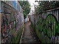
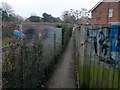
Boscombe: graffiti lines both sides of footpath F06
This footpath comes from Wolverton Road (to our sharp left) and has turned a corner for this short segment ending at the railway line (ahead), where it does a very sharp right turn to lead to Gloucester Road.
See Image for the view towards us from ahead, and Image for the next view behind (or rather, to the left) - each with links to further photos on the route.
Image: © Chris Downer
Taken: 11 Feb 2017
0.08 miles
10
Boscombe: footpath F06 goes alongside the railway
This footpath from Wolverton Road has reached the railway line from behind/between houses, and now takes a sharp right turn, running alongside the railway line to reach Gloucester Road.
See Image for the next view on the path ahead, and Image for the next view behind (or rather, to the right) - each with links to further photos on the route.
Image: © Chris Downer
Taken: 11 Feb 2017
0.08 miles