IMAGES TAKEN NEAR TO
Gloucester Road, BOURNEMOUTH, BH7 6HZ
Introduction
This page details the photographs taken nearby to Gloucester Road, BH7 6HZ by members of the Geograph project.
The Geograph project started in 2005 with the aim of publishing, organising and preserving representative images for every square kilometre of Great Britain, Ireland and the Isle of Man.

There are currently over 7.5m images from over14,400 individuals and you can help contribute to the project by visiting https://www.geograph.org.uk
Image Map (Loading...)


Getting Data...Please wait
Leaflet Map data © OpenStreetMap
Images are licensed for reuse under creativecommons.org/licenses/by-sa/2.0
Notes
- Clicking on the map will re-center to the selected point.
- The higher the marker number, the further away the image location is from the centre of the postcode.
Image Listing (148 Images Found)
Images are licensed for reuse under creativecommons.org/licenses/by-sa/2.0
Image
Details
Distance
1
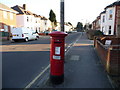
Boscombe: postbox № BH7 69, Gloucester Road
This George VI-reign postbox has a sticker on it stating that from August 2006 the last weekday collection time will be changed to 5:30pm. However, the collection plate has been updated since then, and now concurs.
Image: © Chris Downer
Taken: 28 Dec 2008
0.03 miles
2
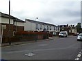
Boscombe Police Station
On Gloucester Road; apparently under review for closure: http://www.bournemouthecho.co.uk/news/8805325.No_decision_yet_on_Boscombe_Police_Station/
Image: © Mike Faherty
Taken: 25 Jun 2011
0.05 miles
3
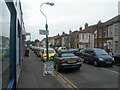
Somerset Road, Boscombe
Photographer was standing on corner of Christchurch Road, looking North.
Image: © Danny P Robinson
Taken: 11 Mar 2006
0.08 miles
4
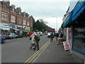
Christchurch Road, Boscombe (2)
This picture was taken at the junction of Somerset Road, photographer was facing Boscombe town centre.
Image: © Danny P Robinson
Taken: 11 Mar 2006
0.08 miles
5

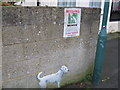
Missing dog poster, Wolverton Road
Is this a Banksy?
Image: © Alex McGregor
Taken: 19 Jan 2012
0.08 miles
6
Found dog, Wolverton Road
Is this a Banksy?
Image: © Alex McGregor
Taken: 19 Jan 2012
0.08 miles
7
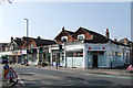
Ripe for development - Christchurch Road, Boscombe (2)
The entire block on the north side of Christchurch Road between Wolverton and Gloucester Road is being demolished in preparation for a new development. Compare this view with the one taken 3 months later:
Image
Image: © Mike Searle
Taken: 18 Mar 2015
0.08 miles
8
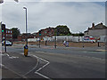
Ripe for development - Christchurch Road, Boscombe (2a)
Demolition of the entire block on this side of Christchurch Road has now been completed with plans already in for about 50 flats to be built on the site. Compare this view with the one taken from the same viewpoint 3 months ago:
Image
Image: © Mike Searle
Taken: 18 Jul 2015
0.08 miles
9
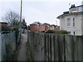
Boscombe: footpath F06 arrives on Gloucester Road
Looking along the final stretch of this public footpath from Wolverton Road as it arrives at its destination. This final leg of the path abuts the railway line, left.
See Image for the view towards us from across the road, and Image for the next view on the path behind, with links to further photos on the route.
Image: © Chris Downer
Taken: 11 Feb 2017
0.09 miles
10
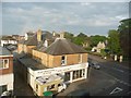
Boscombe: looking down on Christchurch Road
Looking down on a shop on Christchurch Road, the central road through Boscombe, as a rainbow forms in the distance.
Image: © Chris Downer
Taken: 25 May 2009
0.09 miles