IMAGES TAKEN NEAR TO
Gladstone Road East, BOURNEMOUTH, BH7 6HF
Introduction
This page details the photographs taken nearby to Gladstone Road East, BH7 6HF by members of the Geograph project.
The Geograph project started in 2005 with the aim of publishing, organising and preserving representative images for every square kilometre of Great Britain, Ireland and the Isle of Man.

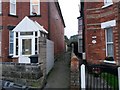
There are currently over 7.5m images from over14,400 individuals and you can help contribute to the project by visiting https://www.geograph.org.uk
Image Map
Images are licensed for reuse under creativecommons.org/licenses/by-sa/2.0
Notes
- Clicking on the map will re-center to the selected point.
- The higher the marker number, the further away the image location is from the centre of the postcode.
Image Listing (159 Images Found)
Images are licensed for reuse under creativecommons.org/licenses/by-sa/2.0
Image
Details
Distance
1
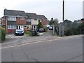
Boscombe Police Station
On Gloucester Road; apparently under review for closure: http://www.bournemouthecho.co.uk/news/8805325.No_decision_yet_on_Boscombe_Police_Station/
Image: © Mike Faherty
Taken: 25 Jun 2011
0.01 miles
2

Missing dog poster, Wolverton Road
Is this a Banksy?
Image: © Alex McGregor
Taken: 19 Jan 2012
0.05 miles
3
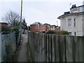
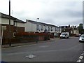
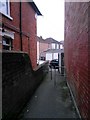
Boscombe: footpath F06 arrives on Gloucester Road
Looking along the final stretch of this public footpath from Wolverton Road as it arrives at its destination. This final leg of the path abuts the railway line, left.
See Image for the view towards us from across the road, and Image for the next view on the path behind, with links to further photos on the route.
Image: © Chris Downer
Taken: 11 Feb 2017
0.05 miles
4
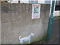
Found dog, Wolverton Road
Is this a Banksy?
Image: © Alex McGregor
Taken: 19 Jan 2012
0.06 miles
5
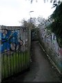
Boscombe: footpath F06 from Gloucester Road
A narrow alley forms a public footpath to Wolverton Road, starting off alongside the railway line before turning left ahead.
See Image for the view towards us from along the path, with links to further photos on the route.
Image: © Chris Downer
Taken: 11 Feb 2017
0.06 miles
6
Boscombe: footpath F06 reaches Wolverton Road
This footpath comes from Gloucester Road and has turned two corners, forming a sort of Z-shape, to reach Wolverton Road just ahead of us.
See Image for the view towards us from the road ahead, and Image for the next view behind, with links to further photos on the route.
Image: © Chris Downer
Taken: 11 Feb 2017
0.06 miles
7
Boscombe: middle section of footpath F06
This footpath from Gloucester Road has come alongside the railway line (directly behind us), and now takes a sharp left turn, running behind/between houses on its way to Wolverton Road. This is thus a very short section between the two turns.
See Image for the next view on the path ahead, and Image for the next view behind (or rather, to the left) - each with links to further photos on the route.
Image: © Chris Downer
Taken: 11 Feb 2017
0.06 miles
8
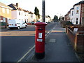
Boscombe: postbox № BH7 69, Gloucester Road
This George VI-reign postbox has a sticker on it stating that from August 2006 the last weekday collection time will be changed to 5:30pm. However, the collection plate has been updated since then, and now concurs.
Image: © Chris Downer
Taken: 28 Dec 2008
0.06 miles
9
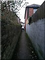
Boscombe: footpath F06 heads for Wolverton Road
This footpath comes from Gloucester Road and has turned two corners, forming a sort of Z-shape, to reach this final straight to Wolverton Road.
See Image for the next view on the path ahead, and Image for the next view behind - each with links to further photos on the route.
Image: © Chris Downer
Taken: 11 Feb 2017
0.07 miles
10
Boscombe: footpath F06 from Wolverton Road
This footpath heads for Gloucester Road, starting off here between 66 and 66a Wolverton Road and eventually running alongside the railway for its last stretch.
See Image for the view towards us from along the path ahead, with links to further photos on the route.
Image: © Chris Downer
Taken: 11 Feb 2017
0.07 miles