IMAGES TAKEN NEAR TO
Portman Road, BOURNEMOUTH, BH7 6EU
Introduction
This page details the photographs taken nearby to Portman Road, BH7 6EU by members of the Geograph project.
The Geograph project started in 2005 with the aim of publishing, organising and preserving representative images for every square kilometre of Great Britain, Ireland and the Isle of Man.

There are currently over 7.5m images from over14,400 individuals and you can help contribute to the project by visiting https://www.geograph.org.uk
Image Map
Images are licensed for reuse under creativecommons.org/licenses/by-sa/2.0
Notes
- Clicking on the map will re-center to the selected point.
- The higher the marker number, the further away the image location is from the centre of the postcode.
Image Listing (160 Images Found)
Images are licensed for reuse under creativecommons.org/licenses/by-sa/2.0
Image
Details
Distance
1
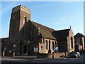
Boscombe: St. George?s Methodist Church
A church with a distinctive tower, on the corner of Portman and Haviland Roads.
Image: © Chris Downer
Taken: 13 Jul 2008
0.01 miles
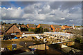
2
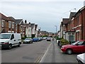
Portman Rd Boscombe
A relatively quiet residential street that gets crowded due to the lack of parking. Just off Christchurch Rd near its junction with Ashley Rd
Image: © Nigel Mykura
Taken: 12 May 2009
0.01 miles
3
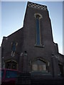
Bournemouth : Boscombe - St. George?s Methodist Church
Image: © Lewis Clarke
Taken: 22 Apr 2009
0.01 miles
4
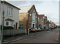
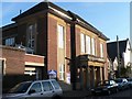
Boscombe, cadet centre
In Portman Road; meeting place for Bournemouth Detachment, ACF, and 130 (Bournemouth) Squadron, ATC.
Image: © Mike Faherty
Taken: 31 Oct 2009
0.02 miles
5
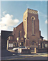
St George Methodist Church, Boscombe
Erected in 1931.
Image: © Michael FORD
Taken: Unknown
0.02 miles
6
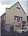
Boscombe: St. George?s Wellspring Centre
A church hall building attached, literally and figuratively, to Image It is referred to in the 1975 Kelly's Directory as the Shrubsall Hall, and this wording is still discernible in the remains of screw-holes above the columns.
Image: © Chris Downer
Taken: 13 Jul 2008
0.04 miles
7
Former Church in Haviland Road, Boscombe
Now used as a Dance Studio.
Image: © Michael FORD
Taken: Unknown
0.04 miles
8
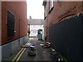
Boscombe: stuff dumped across footpath F07
A narrow alley forms this public footpath from the main Christchurch Road, but this half from Haviland Road incorporates a tight driveway to some rear shop yards. Some dumped rubbish has become strewn across the driveway here, creating a rather unsightly mess.
See Image for the view towards us from across the road ahead, and Image for the next view behind us, with links to further photos along the route.
Image: © Chris Downer
Taken: 14 Feb 2017
0.05 miles
9

Fuji airship over Boscombe in 1990
The airship made a brief appearance over Haviland Road Boscombe in 1990.
Image: © Mike Searle
Taken: Unknown
0.05 miles
10
The old Bournemouth Centre for Community Arts (7 of 12)
Building has commenced on the east side of the site.
Image
Image: © Mike Searle
Taken: 2 Feb 2014
0.05 miles